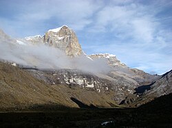
Ritacuba Blanco
| Ritacuba Blanco | |
| Alto Ritacuba, Alto Ritacuva | |
| Bergstopp | |
| Land | |
|---|---|
| Departement | Boyacá |
| Höjdläge | 5 410 m ö.h. |
| Koordinater | 6°29′39″N 72°17′51″V / 6.49417°N 72.29750°V |
| Tidszon | COT (UTC-5) |
| Geonames | 3670694 |
Läge i Colombia | |
Ritacuba Blanco är den högsta bergstoppen i Östkordiljäran, med höjden 5 410 meter över havet. Den ligger i departementet Boyacá i Colombia.[1][2]
Trakten runt Ritacuba Blanco består i huvudsak av kala bergstoppar och isformationer.[3]
Källor
- ^ Alto Ritacuba at GeoNames.Org (cc-by); post uppdaterad 2012-01-19; databasdump nerladdad 2015-05-23
- ^ ”Viewfinder Panoramas Digital elevation Model”. http://www.viewfinderpanoramas.org/dem3.html. Läst 21 juni 2015.
- ^ ”NASA Earth Observations: Land Cover Classification”. NASA/MODIS. Arkiverad från originalet den 28 februari 2016. https://web.archive.org/web/20160228161657/http://neo.sci.gsfc.nasa.gov/view.php?datasetId=MCD12C1_T1. Läst 30 januari 2016.
Media som används på denna webbplats
Shiny red button/marker widget. Used to mark the location of something such as a tourist attraction.
Författare/Upphovsman: Grundkarte Milenioscuro, Relief Alexrk2, Licens: CC BY-SA 3.0
Physical Location map of Colombia Equirectangular projection. Geographic limits of the map:
Författare/Upphovsman: Martin Roca, Licens: CC BY-SA 3.0
Ritacuba Blanco, seen from the Valle de Cojines (Southeast).


