Richland, Washington
| Richland | ||
| Stad (city) | ||
Vy över centrala Richland år 2018 | ||
| ||
| Land | ||
|---|---|---|
| Delstat | ||
| County | Benton County | |
| Höjdläge | 117 m ö.h. | |
| Koordinater | 46°16′50″N 119°16′31″V / 46.28056°N 119.27528°V | |
| Area | 110,38 km² (2020)[2] | |
| - land | 101,6 km² (2020) | |
| - vatten | 8,78 km² (2020) | |
| Folkmängd | 60 560 (2020)[3][4] | |
| Befolkningstäthet | 596 invånare/km² | |
| Grundad | 1905 | |
| Borgmästare | Theresa Richardson (2024–)[1] | |
| Tidszon | PST (UTC-8) | |
| - sommartid | PDT (UTC-7) | |
| ZIP-kod | 99352, 99354 | |
| Riktnummer | 509 | |
| GNIS-kod | 1513395 | |
| Geonames | 5808276 | |
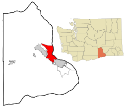
Richland i Benton County och Washington | ||
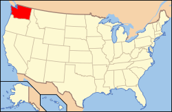
Washingtons läge i USA | ||
| Wikimedia Commons: Richland, Washington | ||
| Webbplats: http://www.ci.richland.wa.us/ | ||
| Redigera Wikidata | ||
Richland är en stad (city) i Benton County i delstaten Washington i USA. Staden hade 60 560 invånare, på en yta av 110,38 km² (2020).[5][6]
Referenser
- ^ läs online, www.ci.richland.wa.us , läst: 10 juli 2024.[källa från Wikidata]
- ^ Gazetteer Files – 2020 (på engelska), United States Census Bureau, läs online, läst: 17 november 2021.[källa från Wikidata]
- ^ Explore Census Data – Richland city, Washington (på engelska), United States Census Bureau, läs online, läst: 17 november 2021.[källa från Wikidata]
- ^ United States Census Bureau (red.), USA:s folkräkning 2020, läs online, läst: 1 januari 2022.[källa från Wikidata]
- ^ ”Explore Census Data – Richland city, Washington” (på engelska). United States Census Bureau. https://data.census.gov/cedsci/profile?g=1600000US5358235. Läst 17 november 2021.
- ^ ”Gazetteer Files – 2020” (på engelska). United States Census Bureau. https://www.census.gov/geographies/reference-files/time-series/geo/gazetteer-files.2020.html. Läst 17 november 2021.
Externa länkar
 Wikimedia Commons har media som rör Richland.
- Officiell webbplats
Media som används på denna webbplats
Författare/Upphovsman: This version: uploader
Base versions this one is derived from: originally created by en:User:Wapcaplet, Licens: CC BY 2.0
Map of USA with Washington highlighted
Författare/Upphovsman: Arkyan, Licens: CC BY-SA 3.0
This map shows the incorporated and unincorporated areas in Benton County, Washington, highlighting Richland in red. It was created with a custom script with US Census Bureau data and modified with Inkscape.
Författare/Upphovsman: Howpper, Licens: CC BY-SA 4.0
.svg of the Richland City Flag. Some of the letters may be off. The white gap represents the Yakima River, which runs through the city.
Författare/Upphovsman: Corbin Harder, Licens: CC BY-SA 4.0
Downtown Richland, next to the Columbia River.


