Rhondda Cynon Taf
| Den här artikeln behöver källhänvisningar för att kunna verifieras. (2022-04) Åtgärda genom att lägga till pålitliga källor (gärna som fotnoter). Uppgifter utan källhänvisning kan ifrågasättas och tas bort utan att det behöver diskuteras på diskussionssidan. |
| Rhondda Cynon Taf | |
| Kommun, county borough | |
(c) Jaggery, CC BY-SA 2.0 Tonypandy | |
| Land | |
|---|---|
| Riksdel | Wales |
| Bevarat grevskap | Mid Glamorgan |
| Administrativ huvudort | Tonypandy |
| Yta | 424 km²[1] |
| Folkmängd | 239 018 (2022)[2] |
| Befolkningstäthet | 564 invånare/km² |
| Tidszon | GMT (UTC+0) |
| - sommartid | BST (UTC+1) |
| GSS-kod | W06000016 |
| Geonames | 3333247 |
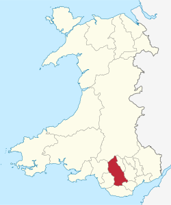
Rhondda Cynon Taf är en kommun (principal area) med county borough-status i södra Wales, i området South Wales Valleys. Kommunen gränsar till Merthyr Tydfil, Caerphilly, Vale of Glamorgan, Bridgend och Powys. Huvudort är Tonypandy.
Kommunen upprättades den 1 april 1996 genom sammanslagning av distrikten Cynon Valley, Rhondda och delar av Taff-Ely. De har också givit namn åt kommunen.
Orter i Rhondda Cynon Taf
- Aberdare
- Glyncoch
- Hirwaun
- Llanharan
- Llantrisant
- Maerdy
- Mountain Ash
- Pontypridd
- Porth
- Tonypandy
- Tonyrefail
- Treherbert
- Ynysybwl
Communites i Rhondda Cynon Taf
För visst lokalt självstyre är Rhondda Cynon Taf indelat i 39 communities:
- Aberaman North
- Aberaman South
- Abercynon
- Aberdare East
- Aberdare West
- Cwm Clydach
- Cwmbach
- Cymmer
- Ferndale
- Gilfach Goch
- Hirwaun
- Llanharan
- Llanharry
- Llantrisant
- Llantwit Fardre
- Llwydcoed
- Llwynypia
- Maerdy
- Mountain Ash East
- Mountain Ash West
- Pen-y-Graig
- Pen-y-Waun
- Penrhiwceiber
- Pentre
- Pontyclun
- Pontypridd
- Porth
- Rhigos
- Taffs Well
- Tonypandy
- Tonyrefail
- Trealaw
- Trehafod
- Treherbert
- Treorchy
- Tylorstown
- Ynyshir
- Ynysybwl and Coed-y-Cwm
- Ystrad
Källor
- ^ ”Standard Area Measurements for Administrative Areas (December 2023) in the UK” (på engelska) (zip). Office for National Statistics. 31 maj 2024. https://geoportal.statistics.gov.uk/datasets/ons::standard-area-measurements-for-administrative-areas-december-2023-in-the-uk/about. Läst 7 juni 2024.
- ^ ”Estimates of the population for the UK, England, Wales, Scotland, and Northern Ireland (Mid-2022)” (på engelska) (xls). Office for National Statistics. 26 mars 2024. https://www.ons.gov.uk/peoplepopulationandcommunity/populationandmigration/populationestimates/datasets/populationestimatesforukenglandandwalesscotlandandnorthernireland. Läst 25 juni 2024.
| |||||||
Media som används på denna webbplats
Författare/Upphovsman: Tkgd2007, Licens: CC BY-SA 3.0
A new incarnation of Image:Question_book-3.svg, which was uploaded by user AzaToth. This file is available on the English version of Wikipedia under the filename en:Image:Question book-new.svg
(c) Jaggery, CC BY-SA 2.0
Tonypandy War Memorial. Tonypandy War Memorial is a cenotaph located inside an enclosure at the edge of Dunraven Street, near the corner of Gilfach Road.
Författare/Upphovsman: TUBS
Location of unitary authority area Rhondda Cynon Taf in Wales in Wales.


