Reno
- För andra betydelser, se Reno (olika betydelser).
| Reno | ||
| Stad (city) | ||
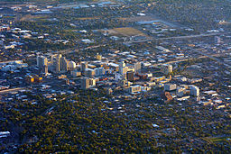
(c) Photograph by D Ramey Logan, CC BY-SA 4.0 Vy över Reno | ||
| ||
| Uppkallad efter: Jesse L. Reno | ||
| Land | ||
|---|---|---|
| Delstat | ||
| County | Washoe County | |
| Höjdläge | 1 373 m ö.h. | |
| Koordinater | 39°31′34″N 119°48′46″V / 39.52611°N 119.81278°V | |
| Area | 289,06 km² (2020)[2] | |
| - land | 281,72 km² (2020) | |
| - vatten | 7,34 km² (2020) | |
| Folkmängd | 264 165 (2020)[3][4] | |
| Befolkningstäthet | 938 invånare/km² | |
| Grundad | 1868 | |
| Borgmästare | Hillary Schieve (2014–)[1] | |
| Tidszon | PST (UTC-8) | |
| - sommartid | PDT (UTC-7) | |
| ZIP-kod | 89501–89503, 89506, 89509, 89511, 89512, 89519, 89521, 89523 | |
| Riktnummer | 775 | |
| GNIS-kod | 861100 | |
| Geonames | 5511077 | |
Reno i Washoe County och Nevada | ||
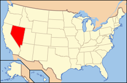
Nevadas läge i USA | ||
| Wikimedia Commons: Reno, Nevada | ||
| Webbplats: https://www.reno.gov | ||
| Redigera Wikidata | ||
Reno är en stad (city) i Washoe County i delstaten Nevada i USA. Staden är tredje folkrikast i delstaten med 264 165 invånare, på en yta av 289,06 km² (2020).[5][6] Reno är administrativ huvudort (county seat) i Washoe County.
Staden ligger i delstatens västra del och är sammanväxt med Sparks i öster. Den är belägen cirka 15 kilometer öster om gränsen mot Kalifornien samt cirka 550 kilometer nordväst om Las Vegas.
Reno fick viss uppmärksamhet i och med tv-serien "Reno 911!", trots att serien inte spelades in i Reno. Reno blev känt för det stora antalet människor som strömmade till staden för att skilja sig från 1931 till 1970-talet, tack vare delstaten Nevadas liberala skilsmässolagstiftning.[7]
Utbildning
Universitet och college
University of Nevada är det största och äldsta universitetet i Nevada.
Privata skolor
Reno har ett fåtal privata grundskolor, såsom Legacy Christian School, Excel Christian School och Lamplight Christian School[8]. I staden finns också några privata high schools, däribland Bishop Manogue High School som är den största[9] och Sage Ridge School (SRS).[10]
Referenser
- ^ läs online, www.reno.gov , läst: 9 maj 2022.[källa från Wikidata]
- ^ Gazetteer Files – 2020 (på engelska), United States Census Bureau, läs online, läst: 20 december 2021.[källa från Wikidata]
- ^ Explore Census Data – Reno city, Nevada (på engelska), United States Census Bureau, läs online, läst: 20 december 2021.[källa från Wikidata]
- ^ United States Census Bureau (red.), USA:s folkräkning 2020, läs online, läst: 1 januari 2022.[källa från Wikidata]
- ^ ”Explore Census Data – Reno city, Nevada” (på engelska). United States Census Bureau. https://data.census.gov/cedsci/profile?g=1600000US3260600. Läst 20 december 2021.
- ^ ”Gazetteer Files – 2020” (på engelska). United States Census Bureau. https://www.census.gov/geographies/reference-files/time-series/geo/gazetteer-files.2020.html. Läst 20 december 2021.
- ^ Brean, Henry. ”The rise and fall of Reno's quickie divorce industry” (på amerikansk engelska). Reno Gazette Journal. https://www.rgj.com/story/life/2017/09/18/rise-and-fall-renos-quickie-divorce-industry/677065001/. Läst 14 november 2022.
- ^ ”Lamplight Christian School”. Arkiverad från originalet den 29 oktober 2013. https://web.archive.org/web/20131029232200/http://www.lcsreno.com/. Läst 11 maj 2011.
- ^ Bishop Manogue Catholic High School – Home
- ^ Sage Ridge School
Externa länkar
 Wikimedia Commons har media som rör Reno.
- Officiell webbplats
| ||||||||||
Media som används på denna webbplats
Flag of the State of Nevada. The flag is described in Nevada Revised Statutes Chapter 235, Sec. 20 as follows: The body of the flag must be of solid cobalt blue. On the field in the upper left quarter thereof must be two sprays of Sagebrush with the stems crossed at the bottom to form a half wreath. Within the sprays must be a five-pointed silver star with one point up. The word “Nevada” must also be inscribed below the star and above the sprays, in a semicircular pattern with the letters spaced apart in equal increments, in the same style of letters as the words “Battle Born.” Above the wreath, and touching the tips thereof, must be a scroll bearing the words “Battle Born.” The scroll and the word “Nevada” must be golden-yellow. The lettering on the scroll must be black-colored sans serif gothic capital letters.
Författare/Upphovsman: This version: uploader
Base versions this one is derived from: originally created by Wapcaplet, Licens: CC BY 2.0
Locator map of Nevada — in the Western United States.
Författare/Upphovsman: Arkyan, Licens: CC BY-SA 3.0
This map shows the incorporated and unincorporated areas in Washoe County, Nevada.
- Highlighting Reno in red.
It was created with a custom script with US Census Bureau data and modified with Inkscape.
(c) Photograph by D Ramey Logan, CC BY-SA 4.0
Reno, Nevada photo D Ramey Logan


