Rennebu kommun
| Rennebu kommun | |||
| Rennebu kommune | |||
| Kommun | |||
.JPG) Rennebu kommunhus i Berkåk. | |||
| |||
| Land | |||
|---|---|---|---|
| Fylke | Trøndelag fylke | ||
| Koordinater | 62°49′51″N 9°52′28″Ö / 62.83083°N 9.87444°Ö | ||
| Centralort | Berkåk | ||
| Area | 947,96 km² (2020)[3] | ||
| - land | 923,85 km² (2020) | ||
| - vatten | 24,11 km² | ||
| Folkmängd | 2 481 (2023)[4] | ||
| Befolkningstäthet | 3 invånare/km² | ||
| Grundad | 1839[1] | ||
| - Utbruten ur | Meldals kommun[1] | ||
| - Tillförda områden | Kvikne kommun (1966)[2] Tynsets kommun (1970)[2] | ||
| Politik | |||
| - Kommunstyrelsens ordförande | Ola Øie (2015–) | ||
| Tidszon | CET (UTC+1) | ||
| - sommartid | CEST (UTC+2) | ||
| Kommunkod | 5022 (2018–) 1635 (–2017) | ||
| Geonames | 3141967 | ||
| Målform | bokmål och nynorska | ||
 Rennebu kommun i Trøndelag fylke. | |||
 (c) Karte: NordNordWest, Lizenz: Creative Commons by-sa-3.0 de Trøndelag fylke i Norge. | |||
| Wikimedia Commons: Rennebu | |||
| Webbplats: https://www.rennebu.kommune.no/ | |||
| Redigera Wikidata | |||
Rennebu kommun (norska: Rennebu kommune) är en kommun i Trøndelag fylke i mellersta Norge. Kommunens centralort är tätorten Berkåk.
Administrativ historik
Rennebu kommun upprättades 1839 genom utbrytning ur Meldals kommun. Kommunen hade 2 368 invånare vid upprättandet.[5]
Den 1 januari 1966 överfördes ett bebott område (Innsets socken med 420 invånare) från den då upplösta Kvikne kommun till Rennebu kommun. Området fördes samtidigt över från Hedmark fylke till Sør-Trøndelag fylke.[5]
Den 1 januari 1970 överfördes ett bebott område (del av fastigheten Garlia med 5 invånare) från Tynsets kommun till Rennebu kommun. Området fördes samtidigt över från Hedmark fylke till Sør-Trøndelag fylke.[5]
Den 1 januari 2018 bytte kommunen både fylke och kommunkod när Sør-Trøndelag fylke blev en del av det då upprättade Trøndelag fylke.
Kommunvapen
Blasonering: I gull ein svevande omvend raud gaffelkross.[6]
(I fält av guld ett störtat rött svävande gaffelkors.)
Kommunvapnet godkändes genom kunglig resolution den 19 februari 1982. Gaffelkorset återspeglar först och främst den Y-formade Rennebu kyrka, som är Norges äldsta i sitt slag, byggd 1669. Den omvända bokstaven representerar samtidigt också bygdens form i stora drag.[7]
Tätorter
I Rennebu kommun finns en tätort:[8]
- Berkåk (centralort)
Socknar
Inom Norska kyrkan är Rennebu kommun indelad i tre socknar:[9]
- Berkåks socken
- Innsets socken
- Rennebu socken
Socknarna ingår i Gauldals prosteri i Nidaros stift.[9]
Bilder
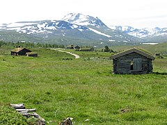 Jøldalen vid Trollheimen.
 Vy från toppen av Ilfjellet (1218 m ö.h.).
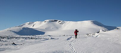 Svarthøtta (1548 m ö.h.).
Källor
- ^ [a b] Dag Juvkam, Historisk oversikt over endringer i kommune- og fylkesinndelingen, Statistisk sentralbyrå, maj 1999, s. 65, ISBN 82-537-4684-9, läs online.[källa från Wikidata]
- ^ [a b] Dag Juvkam, Historisk oversikt over endringer i kommune- og fylkesinndelingen, Statistisk sentralbyrå, maj 1999, s. 68, ISBN 82-537-4684-9, läs online.[källa från Wikidata]
- ^ Statens kartverk, Arealstatistikk for Norge 2020, Statens kartverk, 20 december 2019, läs online.[källa från Wikidata]
- ^ 07459: Alders- og kjønnsfordeling i kommuner, fylker og hele landets befolkning (K) 1986 - 2023 (på norskt bokmål), Statistisk sentralbyrå, 21 februari 2023, läs online.[källa från Wikidata]
- ^ [a b c] ”Historisk oversikt over endringer i kommune- og fylkesinndelingen” (PDF). Statistisk sentralbyrå. Maj 1999. https://www.ssb.no/a/publikasjoner/pdf/rapp_9913/rapp_9913.pdf.
- ^ Europeana Heraldica
- ^ Digitalarkivet
- ^ Kart fra Statistisk sentralbyrå
- ^ [a b] Store norske leksikon
Externa länkar
- Officiell webbplats
 Wikimedia Commons har media som rör Rennebu kommun.
| ||||||||||
| ||||||||||
Media som används på denna webbplats
.svg)
Författare/Upphovsman: Gutten på Hemsen, Licens: CC0
Flag of Norway with colors from the previous version on Commons. This file is used to discuss the colors of the Norwegian flag.
(c) Karte: NordNordWest, Lizenz: Creative Commons by-sa-3.0 de
Location of county Trøndelag in Norway (2024)

Coat of arms for Nord-Trøndelag; until 31 December 2017 county (fylke), Norway
Författare/Upphovsman: Bjarkan, Licens: CC BY-SA 4.0
Map showing the position of the municipality of Rennebu within the county of Trøndelag in Norway.

Författare/Upphovsman: Ole-ph, Licens: CC BY-SA 3.0
Fjellet Svarthetta (1548 moh) i Trollheimen, Sør-Trøndelag. Bildet er tatt østfra

Författare/Upphovsman: Hhtg, Licens: CC BY-SA 4.0
Ilfjell, Norway, Trøndelag, view from the peak.

Flag of Rennebu municipality

Kommunevåpen for Rennebu kommune i Sør-Trøndelag fylke.

Coat of arms for Sør-Trøndelag county (fylke), Norway

Författare/Upphovsman: Orcaborealis, Licens: CC BY-SA 3.0
Jøldalen valley in the Trollheimen mountain range. Picture taken along the path which goes from Jølhaugen (car park) to Jøldalshytta mountain lodge (not in picture). This valley was, and partly still is, used as pasture. Rennebu municipality, Sør-Trøndelag county, Norway.
Norsk: Jøldalen på vei fra Jølhaugen inn til Jøldalshytta (ikke i bildet). Tidligere seterdal. Rennebu kommune, Sør-Trøndelag. Juli 2008.Författare/Upphovsman: Ezzex, Licens: CC BY-SA 3.0
Rennebu rådhus. The municipal building in Rennebu, Norway.