Ranong (provins)
| Den här artikeln behöver fler eller bättre källhänvisningar för att kunna verifieras. (2019-10) Åtgärda genom att lägga till pålitliga källor (gärna som fotnoter). Uppgifter utan källhänvisning kan ifrågasättas och tas bort utan att det behöver diskuteras på diskussionssidan. |
| Ranong (ระนอง) | |||
| Provins | |||
Suwannakhiri tempel | |||
| |||
| Officiellt namn: ระนอง | |||
| Land | |||
|---|---|---|---|
| Region | Södra Regionen | ||
| Provinshuvudstad | Ranong | ||
| - koordinater | 09°57′43″N 98°38′20″Ö / 9.96194°N 98.63889°Ö | ||
| Area | 3 298,0 km²[1] | ||
| Folkmängd | 161 210 (2000) | ||
| Befolkningstäthet | 49 invånare/km² | ||
| Tidszon | ICT (UTC+7) | ||
| Geonames | 1150964 | ||
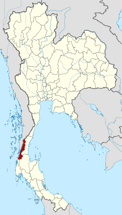
Ranongs läge i Thailand. | |||
Ranong, (thai: ระนอง) är en provins (changwat) i södra Thailand. Provinsen hade år 2000 161 210 invånare på en areal av 3 298,0 km². Provinshuvudstaden är Ranong.
Administrativ indelning
Provinsen är indelad i 5 distrikt (amphoe). Distrikten är i sin tur indelade i 30 subdistrikt (tambon) och 167 byar (muban).
 |
|
|
Referenser
Externa länkar
 Wikimedia Commons har media som rör provinsen Ranong.
| |||||||||||||||||||||||
Media som används på denna webbplats
Författare/Upphovsman: Tkgd2007, Licens: CC BY-SA 3.0
A new incarnation of Image:Question_book-3.svg, which was uploaded by user AzaToth. This file is available on the English version of Wikipedia under the filename en:Image:Question book-new.svg
The national flag of Kingdom of Thailand; there are total of 3 colours:
- Red represents the blood spilt to protect Thailand’s independence and often more simply described as representing the nation.
- White represents the religion of Buddhism, the predominant religion of the nation
- Blue represents the monarchy of the nation, which is recognised as the centre of Thai hearts.
ธงประจำจังหวัดระนอง
Provincial seal of the Ranong province, Thailand.
Författare/Upphovsman: NordNordWest, Licens: CC BY 3.0
Locator map of Ranong Province, Thailand
Författare/Upphovsman: KOSIN SUKHUM, Licens: CC BY-SA 4.0
This is a photo of a monument in Thailand identified by the ID
Författare/Upphovsman: Ahoerstemeier, Licens: CC BY-SA 3.0
Map of Ranong province, Thailand, with the district (Amphoe) numbered.
- Mueang Ranong (อำเภอเมืองระนอง)
- La-un (อำเภอละอุ่น)
- Kapoe (อำเภอกะเปอร์)
- Kra Buri (อำเภอกระบุรี)
- Suk Samran (sub-district) (กิ่งอำเภอสุขสำราญ)


