Raisen (distrikt)
| Raisen | |
| Distrikt | |
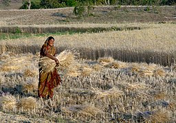
This file is not in the public domain. Therefore you are requested to use the following next to the image if you reuse this file: © Yann Forget / Wikimedia Commons, CC BY-SA 3.0 Kvinna som skördar vete i distriktet Raisen. | |
| Land | |
|---|---|
| Delstat | Madhya Pradesh |
| Höjdläge | 565 m ö.h. |
| Koordinater | 23°15′00″N 78°05′00″Ö / 23.25°N 78.08333°Ö |
| Folkmängd | 1 331 597 (2016-07-04)[1] |
| Tidszon | IST (UTC+5:30) |
| Geonames | 1258953 |
Läge i Indien | |
Raisen är ett distrikt i Indien.[1] Det ligger i delstaten Madhya Pradesh, i den centrala delen av landet, 600 km söder om huvudstaden New Delhi. Antalet invånare är 1 331 597.[1]
Följande samhällen finns i Raisen:
Källor
- ^ [a b c] Raisen hos Geonames.org (cc-by); post uppdaterad 2016-07-04; databasdump nerladdad 2016-08-15
Media som används på denna webbplats
Shiny red button/marker widget. Used to mark the location of something such as a tourist attraction.
This file is not in the public domain. Therefore you are requested to use the following next to the image if you reuse this file: © Yann Forget / Wikimedia Commons, CC BY-SA 3.0
Woman harvesting wheat, Raisen district, Madhya Pradesh, India.
Författare/Upphovsman: Uwe Dedering, Licens: CC BY-SA 3.0
Location map of India.
Equirectangular projection. Stretched by 106.0%. Geographic limits of the map:
- N: 37.5° N
- S: 5.0° N
- W: 67.0° E
- E: 99.0° E


