Queen Alexandra Range
| Queen Alexandra Range | |
| Bergskedja | |
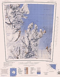
Karta över bergskedjans norra del. | |
| Kontinent | |
|---|---|
| Höjdläge | 1 486 m ö.h. |
| Koordinater | 84°44′00″S 168°00′00″Ö / 84.73333°S 168.0°Ö |
| Geonames | 6623774 |
Queen Alexandra Range är en bergskedja i Östantarktis.[1] Nya Zeeland gör anspråk på området.
Källor
- ^ Queen Alexandra Range at GeoNames.Org (cc-by); post uppdaterad 2008-01-20; databasdump nerladdad 2015-11-07
Media som används på denna webbplats
Shiny red button/marker widget. Used to mark the location of something such as a tourist attraction.
Författare/Upphovsman: Tobias Jakobs (in the public domain)., Licens: CC0
One of several flag proposals for Antarctica.
1:250,000-scale topographic reconnaissance map of the Mount Elizabeth area from 165°-172°30'E to 83°-84°S in Antarctica. Mapped, edited and published by the U.S. Geological Survey in cooperation with the National Science Foundation.
Författare/Upphovsman: Alexrk2, Licens: CC BY-SA 3.0
Physical Location map Antarctica, Azimuthal equidistant projection


