Pulaski County, Illinois
| Pulaski County | |
| County | |
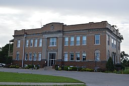
Pulaski Countys domstolshus i Mound City. | |
| Land | |
|---|---|
| Delstat | |
| Huvudort | Mound City |
| Area | 526 km² (2010)[1] |
| - land | 516 km² (98%) |
| - vatten | 10,5 km² (2%) |
| Folkmängd | 6 161 (2010)[2] |
| Befolkningstäthet | 12 invånare/km² |
| Grundat | 1843 |
| - uppkallat efter | Kazimierz Pułaski |
| Tidszon | CST (UTC-6) |
| - sommartid | CDT (UTC-5) |
| FIPS-kod | 17153 |
| Geonames | 4247655 |
Läge i delstaten Illinois. | |
Delstatens läge i USA. | |
Pulaski County är ett administrativt område i delstaten Illinois, USA, med 6 161 invånare. Den administrativa huvudorten (county seat) är Mound City.
Geografi
Enligt United States Census Bureau har countyt en total area på 527 km². 520 km² av den arean är land och 7 km² är vatten.
Angränsande countyn
- Union County - nord
- Johnson County - nordost
- Massac County - öst
- Ballard County, Kentucky - sydost
- Alexander County - väst
Referenser
- ^ ”2010 Census U.S. Gazetteer Files for Counties”. U.S. Census Bureau. Arkiverad från originalet den 5 juli 2012. https://www.webcitation.org/68vYLbou5?url=http://www.census.gov/geo/www/gazetteer/files/Gaz_counties_national.txt. Läst 5 juli 2012.
- ^ ”State & County QuickFacts, Pulaski County, Illinois” (på engelska). U.S. Census Bureau. Arkiverad från originalet den 17 juli 2011. https://www.webcitation.org/60F4P8M9r?url=http://quickfacts.census.gov/qfd/states/17/17153.html. Läst 6 juli 2011.
|
Media som används på denna webbplats
Författare/Upphovsman: This version: uploader
Base versions this one is derived from: originally created by en:User:Wapcaplet, Licens: CC BY 2.0
Map of USA with Illinois highlighted
Front and eastern side of the Pulaski County Courthouse, located at 500 Illinois Avenue in Mound City, Illinois, United States. It was built in 1912.
This is a locator map showing Pulaski County in Illinois. For more information, see Commons:United States county locator maps.


