Prinzapolka
| Prinzapolka | |
| Kommun | |
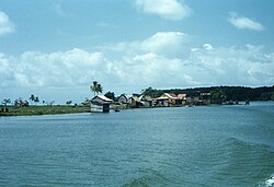
Stranden i Prinzapolka ca 1959 | |
| Land | |
|---|---|
| Autonom Region | Costa Caribe Norte |
| Koordinater | 13°29′50″N 84°13′28″V / 13.497185°N 84.224414°V |
| Centralort | Alamikamba |
| Area | 7 020 km² |
| Folkmängd | 32 490 (2012) |
| Befolkningstäthet | 5 invånare/km² |
| Grundad | 1889 |
| Tidszon | CST (UTC-6) |
| Geonames | 3617168 |
| Känd för[1] | Río Prinzapolka Fisk Suhkru firandet |
| Webbplats: INTUR:Conocé Prinzapolka | |
Prinzapolka är en kommun (municipio) i Nicaragua med 32 490 invånare (2012).[2] Den ligger längs floden Río Prinzapolka i den nordöstra delen av landet i Región Autónoma de la Costa Caribe Norte, vid Karibiska havet. Kommunens huvudnäringar är fiske och skogsbruk.[1]
Geografi
Prinzapolka är den till ytan näst största kommunen i Nicaragua. Den gränsar till kommunerna Puerto Cabezas och Rosita i norr, Siuna i väster, La Cruz de Río Grande och Desembocadura de Río Grande i söder, samt till Karibiska havet i öster.[3] Kommunens centralort Alamikamba, med 1 272 invånare (2005), ligger på norra stranden av floden Prinzapolka.[4]
Historia
Prinzapolka grundades 1889 som ett distrikt (distrito) efter det att guld hade upptäckts längs floden Prinzapolka och ett stort antal guldgrävare anlänt till området. Kommunen Prinzapolka omfattade tidigare större delen av Región Autónoma de la Costa Caribe Norte, inklusive de nuvarande kommunerna Siuna, Waslala, Bonanza, Rosita och Puerto Cabezas, samt den norra delen av Mulukukú.[5]
Prinzapolka var tidigare en viktig transportled för stora bananplantager, skogsindustrin och för gruvorna i Siuna, Bonanza och Rosita. Varorna transporterades först längs vägar till Alamikamba eller andra orter längs floden och sedan per båt till hamnen i orten Prinzapolka vid flodens mynning. Nu har hamnen i Bilwi övertagit den rollen.[1]
Bilder
(c) Richard Salgado, CC BY 3.0 | (c) Richard Salgado, CC BY 3.0 |
(c) Richard Salgado, CC BY 3.0 | (c) Richard Salgado, CC BY 3.0 |
 |  |
 |  |
Källor
- ^ [a b c] Juan Echánove och Joaquim Rabella, La guía de Nicaragua, 3a edicón, Editorial Hispamer, 2011.
- ^ Instituto Nacional de Información de Desarrollo, Población Total, estimada al 30 de Junio del año 2012. Arkiverad 2 maj 2013 hämtat från the Wayback Machine.
- ^ Zonu.com, Mapas Departamentos de Nicaragua
- ^ Instituto Nacional de Información de Desarrollo, Censo 2005 Arkiverad 19 augusti 2016 hämtat från the Wayback Machine.
- ^ Darío González, Geografía de la América-Central, Pacific Press Publishing Company, 1896.
Media som används på denna webbplats
Författare/Upphovsman: Alexrk2, Licens: CC BY-SA 3.0
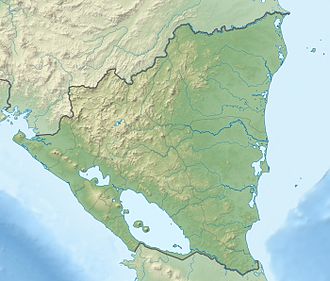
Physical Location map Nicaragua with Departamentos, Equirectangular projection, N/S stretching 100 %. Geographic limits of the map:
Shiny red button/marker widget. Used to mark the location of something such as a tourist attraction.
(c) Richard Salgado, CC BY 3.0
Vista del atardecer desde el Aserrío Las Minas en Llanos de Palmera, Prinzapolka.
Town of Prinzapolka town viewed from Prinazpolka near its mouth on the Caribbean Sea
(c) Richard Salgado, CC BY 3.0
Río Susún en la Comunidad San Martín Yaoya, Prinzapolka, Nicaragua.
View of Prinzapolka dock and beach cabins belonging to La Luz Gold Mine in Siuna and Bonanza.
(c) Richard Salgado, CC BY 3.0
Bosque de la Finca Susún en la Comunidad San Martín Yaoya, Prinzapolka, Nicaragua.
View of Alamacamba on the Prinzapolka during the dry season - where barges of sulfur and sundry mining supplies are off loaded and trucked overland to Siuna and Rosita mines - note the low river level during the dry season which occurs during the winter months
Photo of Prinzapolka dock owned by La Luz Gold Mine in Siuna and Bonanza, for the La Luz Gold Mine complex (1936-1968).
- The town of Siuna, Nicaragua. was the site of La Luz Mining company, which was active from 1936 to 1968. There was migration from other areas of the country to work in the gold mine during these years, including people from the coast and indigenous groups. The mine was shut down in 1968 due to damage of the Ei River Hydro Electric Plant.[1]
(c) Richard Salgado, CC BY 3.0
Pinus hondurensis, Región Autónoma de la Costa Caribe Norte, Nicaragua
Semi-trailers loaded with sulfur for smelting being off loaded in Alamacamba on the Prinzipolka River for transporting the the mines, for the La Luz Gold Mine complex (1936-1968).
- The town of Siuna, Nicaragua was the site of La Luz Mining company, which was active from 1936 to 1968. There was migration from other areas of the country to work in the gold mine during these years, including people from the coast and indigenous groups. The mine was shut down in 1968 due to damage of the Ei River Hydro Electric Plant.[1]


