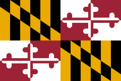
Prince George's County
| Prince George's County | |||
| County | |||
| |||
| Land | |||
|---|---|---|---|
| Delstat | |||
| Huvudort | Upper Marlboro | ||
| Area | 1 292 km² (2010)[1] | ||
| - land | 1 250 km² (97%) | ||
| - vatten | 41,8 km² (3%) | ||
| Folkmängd | 863 420 (2010)[2] | ||
| Befolkningstäthet | 691 invånare/km² | ||
| Grundat | 1696[3] | ||
| - uppkallat efter | prins Georg av Danmark[3] | ||
| Tidszon | EST (UTC-5) | ||
| - sommartid | EDT (UTC-4) | ||
| FIPS-kod | 24033 | ||
| Geonames | 4366164 | ||
 Läge i delstaten Maryland. | |||
Delstatens läge i USA. | |||
| Webbplats: www.princegeorgescountymd.gov | |||
Prince George's County är ett administrativt område i delstaten Maryland, USA, med 863 420 invånare (2005). Den administrativa huvudorten (county seat) är Upper Marlboro.
Countyt grundades 1696 i Provinsen Maryland och är namngiven efter prins Georg av Danmark (1653-1708) som var gemål till drottning Anna av Storbritannien.[3]
Geografi
Prince George's County utgör geografiskt det halvcentrala östra bandet av Washingtons storstadsområde i vilken motorvägsringen The Capital Beltway går igenom.
Enligt United States Census Bureau har countyt en total area på 1 291 km². 1 256 km² av den arean är land och 34 km² är vatten.
I countyt finns militärflygplatsen Joint Base Andrews och nöjesparken Six Flags America.
Angränsande countyn
- Anne Arundel County - öst
- Calvert County - sydöst
- Charles County - syd
- Howard County - nord
- Montgomery County - nordväst
- Fairfax County, Virginia - sydväst
- Alexandria, Virginia - sydväst
- Washington, D.C. - väst
Källor
- ^ ”2010 Census U.S. Gazetteer Files for Counties”. U.S. Census Bureau. Arkiverad från originalet den 5 juli 2012. https://www.webcitation.org/68vYLbou5?url=http://www.census.gov/geo/www/gazetteer/files/Gaz_counties_national.txt. Läst 5 juli 2012.
- ^ ”State & County QuickFacts, Prince George's County, Maryland” (på engelska). U.S. Census Bureau. Arkiverad från originalet den 17 juli 2011. https://www.webcitation.org/60F3la239?url=http://quickfacts.census.gov/qfd/states/24/24033.html. Läst 6 juli 2011.
- ^ [a b c] ”History” (på engelska). www.princegeorgescountymd.gov. Prince George's County. https://www.princegeorgescountymd.gov/1796/History.
Externa länkar
- www.princegeorgescountymd.gov
 Wikimedia Commons har media som rör Prince George's County.
| ||||||||||
|
Media som används på denna webbplats
This is a locator map showing Prince George's County in Maryland.
David Benbennick made this map. For more information, see Commons:United States county locator maps.The flag of Prince George's County, Maryland, as officially defined in the county code. What differentiates it from many currently-used flags is that it uses the 1958 to 1971 county seal in the top left-hand corner instead of the current post-1971 seal. Although it is not as widely used, according to the county code, as of 2018, this is still technically the official flag of the county: "Sec. 1-106. County flag; contents. The official County flag shall be a three (3) feet by five (5) feet flag of white, divided in equal quadrants by four (4) inch stripes of red and containing in its upper left quadrant the official seal of the County as adopted by the Board of Commissioners on November 25, 1958. (Ord. and Res. 1967, Sec. 1-6)". However, in practice, most of the flags manufactured and currently used by the county disregard the county code's description of the flag and instead feature the post-1971 seal in the top left-hand corner. More information about the flag and seal can be found here, here, here, and here.
The official seal of Prince George's County, Maryland; e.g. "P.G. County seal". First created in 1696 by Charles Beckwith of Patuxent, it appears to incorporate a slightly-altered variation of the English Kingdom's Royal Arms from 1603-1707 in its design. The current rendition of the seal was designed in 1971 and was never copyrighted, and thus, it is in the public domain. There are many variants of the seal, possibly due to a lack of standardization. However, this particular version is the closest aesthetically to the one that appears in the county code and thus, the most "official". Additional information about the seal can be found here.
Författare/Upphovsman: This version: uploader
Base versions this one is derived from: originally created by Wapcaplet, Licens: CC BY 2.0
Map of USA with Maryland highlighted


