Prali
| Prali | |
| Kommun | |
| Officiellt namn: Comune di Prali | |
| Land | |
|---|---|
| Region | Piemonte |
| Storstadsregion | Turin |
| Höjdläge | 1 455 m ö.h. |
| Koordinater | 44°53′21″N 7°02′55″Ö / 44.88922°N 7.04851°Ö |
| Yta | 72,61 km²[1] |
| Folkmängd | 242 (2017)[2] |
| Befolkningstäthet | 3 invånare/km² |
| Tidszon | CET (UTC+1) |
| - sommartid | CEST (UTC+2) |
| Postnummer | 10060 |
| Riktnummer | (+39) 0121 |
| ISTAT-kod | 001202 |
| Geonames | 3169953 |
Pralis läge i Italien | |
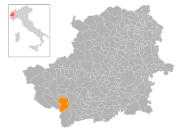
Pralis läge i Turin | |
| Webbplats: Prali | |
Prali är en ort och kommun i storstadsregionen Turin, innan 2015 provinsen Turin, i regionen Piemonte, Italien. Kommunen hade 242 invånare (2017).[2] Orten ligger på 1 454 meters höjd över havet, cirka 72 kilometer sydväst om Turin. Prali gränsar till kommunerna Abriès, Angrogna, Bobbio Pellice, Perrero, Pragelato, Salza di Pinerolo, Sauze di Cesana och Villar Pellice.
Prali var del av arrangemanget i olympiska vinterspelen 2006.
Referenser
- ^ ”Geomorphological characteristics of municipalities”. 2017. Arkiverad från originalet den 16 maj 2019. https://web.archive.org/web/20190516211155/http://dati.istat.it//Index.aspx?QueryId=34711. Läst 5 juli 2019.
- ^ [a b] ”Statistiche demografiche ISTAT”. demo.istat.it. Arkiverad från originalet den 16 juli 2018. https://web.archive.org/web/20180716065929/http://demo.istat.it/bilmens2017gen/index.html. Läst 8 juni 2019.
Externa länkar
 Wikimedia Commons har media som rör Prali.
- Officiell webbplats
Media som används på denna webbplats
Författare/Upphovsman: Eric Gaba (Sting - fr:Sting) and NordNordWest, Licens: CC BY-SA 3.0
Blank physical map of Italy including the 08-2009 modification of the boundary between Emilia-Romagna and Marche regions, for geo-location purpose.
Shiny red button/marker widget. Used to mark the location of something such as a tourist attraction.
The center of Ghigo, commune of Prali, province of Turin
Författare/Upphovsman: Michiel1972 (talk) 21:52, 25 January 2009 (UTC), Licens: CC BY-SA 3.0
- Location maps for the 315 municipalities in province Torino. Boundaries 2001, source Istat.
- Automatically generated with script
- File name contains "Municipality code" (ISTAT-code)
- Created using coordinate data derived from data by ISTAT ([1])


