Portalegre (distrikt)
| Portalegre | |||
| Portugisiskt distrikt | |||
| |||
| Land | |||
|---|---|---|---|
| Region | Alentejo | ||
| Underregion | Alto Alentejo | ||
| Huvudstad | Portalegre | ||
| - koordinater | 39°17′N 7°26′Ö / 39.283°N 7.433°Ö | ||
| Area | 6 065 km² | ||
| Folkmängd | 104 989 (2021) | ||
| Grundad | 1835 | ||
| Geonames | 2264507 | ||
| Antal kommuner | 15 | ||
Distrito de Portalegre är ett av Portugals 18 distrikt vars residensstad är Portalegre.[1][2]
Geografi
Distriktet ligger i mellersta Portugal. Det gränsar i norr till Castelo Branco, i väst till Santarém , i söder till Évora, i öst till Spanien. Distriktet har 127 018 invånare och en yta på 6 065 kvadratkilometer.[2]
Kommuner
Portalegres distrikt omfattar 15 kommuner.[3]
- Alter do Chão
- Arronches
- Avis
- Campo Maior
- Castelo de Vide
- Crato
- Elvas
- Fronteira
- Gavião
- Marvão
- Monforte
- Nisa
- Ponte de Sôr
- Portalegre
- Sousel
Bilder
- Tingsrätten i Ponte de Sor
- Kulturhuset i Elvas
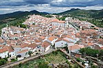
- Castelo de Vide
- Romersk bro i Vila Formosa
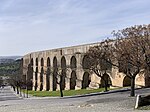
- Akveduten i Elvas
- Kyrkogården i Campo Maior
Se även
Referenser
- ^ ”Portalegre” (på portugisiska). Infopédia. Porto Editora. https://www.infopedia.pt/apoio/artigos/$portalegre. Läst 29 oktober 2022.
- ^ [a b] ”Distrito Portalegre” (på portugisiska). VisitarPortugal – Enciclopédia das Localidades Portuguesas. https://www.visitarportugal.pt/portalegre. Läst 29 oktober 2022.
- ^ ”Município de Portalegre” (på portugisiska). Comunidade Intermunicipal do Alto Alentejo. https://www.cimaa.pt/municipio-de-portalegre/. Läst 29 oktober 2022. ”O distrito conta com 15 concelhos: Alter do Chão, Arronches , Avis, Campo Maior, Castelo de Vide, Crato, Elvas, Fronteira, Gavião, Marvão, Monforte, Nisa, Ponte de Sor, Portalegre e Sousel.”
Externa länkar
 Wikimedia Commons har media som rör Portalegre (distrikt).
| |||||||||||||||||||||
Media som används på denna webbplats
Flag of Portugal, created by Columbano Bordalo Pinheiro (1857–1929), officially adopted by Portuguese government in June 30th 1911 (in use since about November 1910). Color shades matching the RGB values officially reccomended here. (PMS values should be used for direct ink or textile; CMYK for 4-color offset printing on paper; this is an image for screen display, RGB should be used.)
Författare/Upphovsman: Tschubby, Licens: CC BY-SA 3.0
Distrikt Portalegre
Författare/Upphovsman: Ken & Nyetta, Licens: CC BY 2.0
Built by the Romans around 85 AD, it remained the only crossing over the Seda river until 2010! A modern new bridge is about 300 meters behind it. Imagine the millions of people, horses, chariots, cars and semi-tractor trailer trucks that crossed it over the course of over 1,900 years -- and it is still solid as the day it was built. Those Romans did things right.
Författare/Upphovsman: Concierge.2C, Licens: CC BY-SA 3.0
| This file was uploaded for Wiki Loves Monuments in Portugal with the unique identifier 71609.
|
Författare/Upphovsman: Sergei Gussev, Licens: CC BY 2.0
Alentejo, Portugal - February 2020
Författare/Upphovsman: xiquinhosilva from Cacau, Licens: CC BY 2.0
31200-Elvas
Författare/Upphovsman: , Licens: CC BY 2.5
Imagem criada por Rei-artur, em Janeiro de 2005, a partir do mapa Image:Mapa de Portugal completo.
Författare/Upphovsman: Vitor Oliveira from Torres Vedras, PORTUGAL, Licens: CC BY-SA 2.0
Cemitério de Campo Maior - Portugal 🇵🇹
Författare/Upphovsman: Vitor Oliveira from Torres Vedras, PORTUGAL, Licens: CC BY-SA 2.0
<a href="http://loc.alize.us/#/flickr:5662134880" rel="nofollow">See where this picture was taken.</a> <a href="https://www.flickr.com/groups/geotagging/discuss/72157594165549916/">[?]</a>


