Portal:Mars/Arkiv
December
Månadens artikel Mars Reconnaissance Orbiter (MRO) är en rymdsond som USA sände upp den 12 augusti 2005 och som gick in bana runt Mars den 10 mars 2006.
Månadens bild
Bilden är tagen av HiRISE på NASA:s Mars Reconnaissance Orbiter.
November
Månadens artikel Phobos är den större och inre av Mars två månar och har fått sitt namn från den grekiska mytologin efter Phobos, son till krigsguden Ares.
Månadens bild
Bilden är tagen med kameran HiRISE på Mars Reconnaissance Orbiter.
Maj
Månadens artikel
Utforskning av Mars med rymdsonder har pågått sedan 1960-talet. Ingen människa har dock ännu färdats till Mars.
Månadens bild
April
Månadens artikel MER-A, även kallad Spirit, är Nasas första sond i Marsutforskningsprogrammet Mars Exploration Rover Mission. Den landade 3 januari 2004 på Mars yta.
Toppen på Kilimanjaro heter Uhuru Peak, vilket betyder frihet på swahili.
Månadens bild
Opportunity (MER: Mars Exploration Rover)
Media som används på denna webbplats
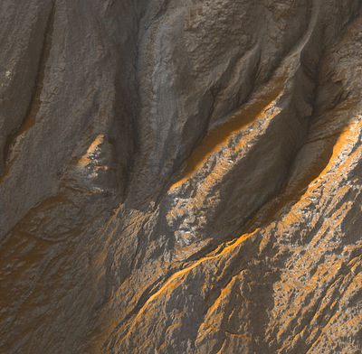
Gullies on a crater wall at Terra Sirenum, Mars. Picture taken by HiRISE on NASA:s Mars Reconnaissance Orbiter. Image centered at -38.9 degrees latitude, 223.7 degrees East longitude. Range to target site was 251.8 km (157.4 miles). The image scale is 50.4 cm/pixel (with 2 x 2 binning) which means objects ~151 cm across are resolved. This image is a part of a larger image which can be found at: http://hiroc.lpl.arizona.edu/images/TRA/TRA_000878_1410/color.html
Mars digital-image mosaic merged with color of the MC-1 quadrangle, Mare Boreum region of Mars. The central part is covered by a residual ice cap that is cut by spiral-patterned troughs exposing layered terrain. The cap is surrounded by broad flat plains and large dune fields. Latitude range 65 to 90, longitude range -180 to 180.
Summary- Mars Rover "Opportunity" at Victoria crater, as viewed from orbit on October 3, 2006. Note the shadow of the rover's camera mast.
Original JPL site caption: "This image from the High Resolution Imaging Science Experiment on NASA's Mars Reconnaissance Orbiter shows the Mars Exploration Rover Opportunity near the rim of "Victoria Crater." Victoria is an impact crater about 800 meters (half a mile) in diameter at Meridiani Planum near the equator of Mars. Opportunity has been operating on Mars since January, 2004. Five days before this image was taken, Opportunity arrived at the rim of Victoria, after a drive of more than 9 kilometers (over 5 miles). It then drove to the position where it is seen in this image.
Shown in the image are "Duck Bay," the eroded segment of the crater rim where Opportunity first arrived at the crater; "Cabo Frio," a sharp promontory to the south of Duck Bay; and "Cape Verde," another promontory to the north. When viewed at the highest resolution, this image shows the rover itself, wheel tracks in the soil behind it, and the rover's shadow, including the shadow of the camera mast. After this image was taken, Opportunity moved to the very tip of Cape Verde to perform more imaging of the interior of the crater.
This view is a portion of an image taken by the High Resolution Imaging Science Experiment (HiRISE) camera onboard the Mars Reconnaissance Orbiter spacecraft on Oct. 3, 2006. The complete image is centered at minus7.8 degrees latitude, 279.5 degrees East longitude. The range to the target site was 297 kilometers (185.6 miles). At this distance the image scale is 29.7 centimeters (12 inches) per pixel (with 1 x 1 binning) so objects about 89 centimeters (35 inches) across are resolved. North is up. The image was taken at a local Mars time of 3:30 PM and the scene is illuminated from the west with a solar incidence angle of 59.7 degrees, thus the sun was about 30.3 degrees above the horizon."This picture was taken by the Viking Lander 1 on February 11, 1978 on Sol 556. The large rock just left of the center is about two meters wide. This rock was named "Big Joe" by the Viking scientists. The top of the rock is covered with red soil. Those portions of the rock not covered are similar in color to basaltic rocks on Earth. Therefore, this may be a fragment of a lava flow that was ejected by an impact crater. The part of the Lander that is visible in the lower left is the cover of the nuclear power supply.


