Port St Mary
| Port St Mary (Purt le Moirrey) | |
| Village | |
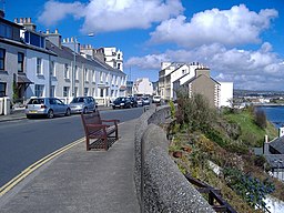
(c) Kevin Rothwell, CC BY-SA 2.0 Bay View Road i Port St Mary | |
| Kronbesittning | |
|---|---|
| Koordinater | 54°04′34″N 4°44′24″V / 54.076°N 4.740°V |
| Area | 1,7 km² |
| Folkmängd | 1 953 (2011)[1] |
| Befolkningstäthet | 1 149 invånare/km² |
| Tidszon | UTC (UTC+0) |
| - sommartid | BST (UTC+1) |
| Geonames | 3042195 |
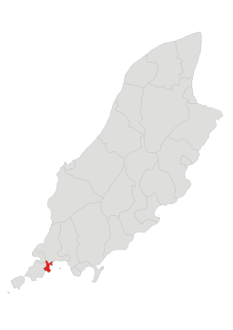
Läge i Isle of Man | |
Port St Mary (manx (språk): Purt le Moirrey) är en ort och ett distrikt på Isle of Man (Storbritannien). Port St Mary ligger på södra delen av Isle of Man, 19 km sydväst om huvudstaden Douglas. Antalet invånare är 1 953.[1]
Källor
- ^ [a b] ”Isle of Man Census Report 2011”. Isle of Man Government Treasury. https://www.gov.im/media/207882/census2011reportfinalresized_1_.pdf. Läst 21 januari 2017.
Media som används på denna webbplats
Författare/Upphovsman: Harrias, Licens: CC BY-SA 3.0
Based upon File:IsleOfMan SheadingsAndParishes-en.svg
Författare/Upphovsman: Fry1989 eh?, Licens: CC0
Flag of the Isle of Mann. This version has the triskelion centered as a whole rather than based upon the imaginary circle created by the prongs of each leg.
(c) Kevin Rothwell, CC BY-SA 2.0
Bay View Road, Port St Mary


