Poplar Bluff
| Poplar Bluff | |
| city | |
| Land | |
|---|---|
| Delstat | Missouri |
| County | Butler County |
| Höjdläge | 110 m ö.h. |
| Koordinater | 36°45′25″N 90°23′34″V / 36.75694°N 90.39278°V |
| Yta | 33,6 km² (2010) |
| - land | 33,4 km² |
| - vatten | 0,2 km² |
| Folkmängd | 17 023 (2010) |
| Befolkningstäthet | 510 invånare/km² |
| Tidszon | CST (UTC-6) |
| - sommartid | CDT (UTC-5) |
| ZIP-kod | 63901, 63902 |
| FIPS | 2959096 |
| Geonames | 4404233 |
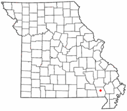
Ortens läge i Missouri | |
Missouris läge i USA | |
| Webbplats: http://www.poplarbluff-mo.gov/ | |
Poplar Bluff är administrativ huvudort i Butler County i Missouri.[1] Ortnamnet har en topografisk förklaring: orten grundades vid ett stup och det växte poppelträd i området.[2]
Källor
- ^ Profile for Poplar Bluff, Missouri Arkiverad 9 maj 2016 hämtat från the Wayback Machine.. ePodunk. Läst 15 april 2016.
- ^ History of Poplar Bluff Arkiverad 28 oktober 2014 hämtat från the Wayback Machine.. City of Poplar Bluff, Missouri. Läst 15 april 2016.
Externa länkar
Media som används på denna webbplats
Författare/Upphovsman: Skye Marthaler, Licens: CC BY-SA 4.0
The city hall of Poplar Bluff, Missouri.
Författare/Upphovsman: User Catbar on en.wikipedia, Licens: CC BY-SA 3.0
Adapted from Wikipedia's MO county maps by Catbar.
- 03:20, 22 May 2004 Catbar 300x263 (13204 bytes) ({{msg:GFDL}}<br>Adapted from Wikipedia's MO county maps by Catbar.)
Författare/Upphovsman: This version: uploader
Base versions this one is derived from: originally created by en:User:Wapcaplet, Licens: CC BY 2.0
Map of USA with Missouri highlighted


