Pontecorvo
| Pontecorvo | ||
| Kommun | ||
| ||
| Officiellt namn: Comune di Pontecorvo | ||
| Land | ||
|---|---|---|
| Region | Lazio | |
| Provins | Frosinone | |
| Höjdläge | 97 m ö.h. | |
| Koordinater | 41°27′42″N 13°40′00″Ö / 41.46162°N 13.66671°Ö | |
| Yta | 88,80 km²[1] | |
| Folkmängd | 13 027 (2018)[2] | |
| Befolkningstäthet | 147 invånare/km² | |
| Tidszon | CET (UTC+1) | |
| - sommartid | CEST (UTC+2) | |
| Postnummer | 03037 | |
| Riktnummer | (+39) 0776 | |
| ISTAT-kod | 060056 | |
| Geonames | 6540539 | |
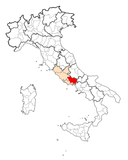
Pontecorvos läge i Italien | ||
Pontecorvos läge i Frosinone | ||
| Webbplats: Pontecorvo | ||
Pontecorvo är en kommun i provinsen Frosinone i regionen Lazio i centrala Italien. Kommunen hade 13 027 invånare (2018).[2]
Historia
Från 1463 till 1860 var Pontecorvo Kyrkostatens exklav i Kungariket Neapel.
1806 erövrades Pontecorvo av Napoleon som förlänade staden som furstendöme, Furstendömet Pontecorvo, till marskalk Jean Baptiste Bernadotte. När denne 1810 utsågs till svensk tronföljare avsade han sig furstendömet mot en utlovad ersättning, som frös inne då Sverige inte anslöts till kontinentalsystemet, Napoleons handelsblockad mot Storbritannien. Sedan Bernadotte 1818 blev kung av Sverige under namnet Karl XIV Johan, har Pontecorvos stadsvapen ingått i Sveriges stora riksvapen.
1810 förlänades Pontecorvo i stället till Neapels kung Joachim Murat, som 1812 lämnade det till sin son Lucien Murat (1803-1878). Efter Wienkongressen återgick staden till Kyrkostaten.[3]
Se även
Externa länkar
Referenser
Noter
- ^ ”Territorial features, Total area (Engelska)”. Istituto Nazionale di Statistica. 2019. http://dati.istat.it/. Läst 4 januari 2020.
- ^ [a b] ”Statistiche demografiche ISTAT”. demo.istat.it. 2018. Arkiverad från originalet den 14 januari 2018. https://web.archive.org/web/20180114115045/http://demo.istat.it/bilmens2018gen/index.html. Läst 4 januari 2020.
- ^ Carlquist, Gunnar, red (1937). Svensk uppslagsbok. Band 21. Malmö: Svensk Uppslagsbok AB. sid. 1003
Övriga källor
- Ponte Corvo i Nordisk familjebok (andra upplagan, 1915)
- Nationalencyklopedin
- Italienskspråkiga Wikipedia
|
Media som används på denna webbplats
Författare/Upphovsman: Eric Gaba (Sting - fr:Sting) and NordNordWest, Licens: CC BY-SA 3.0
Blank physical map of Italy including the 08-2009 modification of the boundary between Emilia-Romagna and Marche regions, for geo-location purpose.
Shiny red button/marker widget. Used to mark the location of something such as a tourist attraction.
Pontecorvo town center view
Map of the Provincia of Frosinone.
Map of the municipality (comune) of Pontecorvo (province of Frosinone, region Lazio, Italien)
Författare/Upphovsman: SanglierT, Licens: CC BY-SA 3.0
d'argent à un pont de gueules à trois arches maçonné de sable surmonté d'un corbeau de sable
The British Army in Italy 1944
The ruined town of Pontecorvo, 26 May 1944.
Text on image file:
THE ADVANCE CONTINUES
On the Eighth Army sector, the enemy were forced to evacuate Pontecorvo, and to draw back north-west along the Liri river as a result of the Canadian penetration of the Hitler line between Pontecorvo and Aquino.
This picture bears testimony to the terrific battering which the enemy received while defending the town of Pontecorvo."


