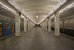
Planernaja
| |||||||||||||||||||||||||||||||||||||||||||||||||||||||||||||||||||||||||||||||||||||||||||||||||||||||||||||||||||||||||||||||||||||||||||||||||||||||||||||||||||||||||||||||||||||||||||||||||||||||||||||||||||||||||||||||||||||
 | |||||||||||||||||||||||||||||||||||||||||||||||||||||||||||||||||||||||||||||||||||||||||||||||||||||||||||||||||||||||||||||||||||||||||||||||||||||||||||||||||||||||||||||||||||||||||||||||||||||||||||||||||||||||||||||||||||||
| Stationsinformation | |||||||||||||||||||||||||||||||||||||||||||||||||||||||||||||||||||||||||||||||||||||||||||||||||||||||||||||||||||||||||||||||||||||||||||||||||||||||||||||||||||||||||||||||||||||||||||||||||||||||||||||||||||||||||||||||||||||
|---|---|---|---|---|---|---|---|---|---|---|---|---|---|---|---|---|---|---|---|---|---|---|---|---|---|---|---|---|---|---|---|---|---|---|---|---|---|---|---|---|---|---|---|---|---|---|---|---|---|---|---|---|---|---|---|---|---|---|---|---|---|---|---|---|---|---|---|---|---|---|---|---|---|---|---|---|---|---|---|---|---|---|---|---|---|---|---|---|---|---|---|---|---|---|---|---|---|---|---|---|---|---|---|---|---|---|---|---|---|---|---|---|---|---|---|---|---|---|---|---|---|---|---|---|---|---|---|---|---|---|---|---|---|---|---|---|---|---|---|---|---|---|---|---|---|---|---|---|---|---|---|---|---|---|---|---|---|---|---|---|---|---|---|---|---|---|---|---|---|---|---|---|---|---|---|---|---|---|---|---|---|---|---|---|---|---|---|---|---|---|---|---|---|---|---|---|---|---|---|---|---|---|---|---|---|---|---|---|---|---|---|---|---|---|---|---|---|---|---|---|---|---|---|---|---|---|---|---|---|
| Tunnelbana | Moskvas tunnelbana | ||||||||||||||||||||||||||||||||||||||||||||||||||||||||||||||||||||||||||||||||||||||||||||||||||||||||||||||||||||||||||||||||||||||||||||||||||||||||||||||||||||||||||||||||||||||||||||||||||||||||||||||||||||||||||||||||||||
| Invigd | 30 december 1975 | ||||||||||||||||||||||||||||||||||||||||||||||||||||||||||||||||||||||||||||||||||||||||||||||||||||||||||||||||||||||||||||||||||||||||||||||||||||||||||||||||||||||||||||||||||||||||||||||||||||||||||||||||||||||||||||||||||||
| Läge | |||||||||||||||||||||||||||||||||||||||||||||||||||||||||||||||||||||||||||||||||||||||||||||||||||||||||||||||||||||||||||||||||||||||||||||||||||||||||||||||||||||||||||||||||||||||||||||||||||||||||||||||||||||||||||||||||||||
| Djup under marknivå | 6 m | ||||||||||||||||||||||||||||||||||||||||||||||||||||||||||||||||||||||||||||||||||||||||||||||||||||||||||||||||||||||||||||||||||||||||||||||||||||||||||||||||||||||||||||||||||||||||||||||||||||||||||||||||||||||||||||||||||||
| |||||||||||||||||||||||||||||||||||||||||||||||||||||||||||||||||||||||||||||||||||||||||||||||||||||||||||||||||||||||||||||||||||||||||||||||||||||||||||||||||||||||||||||||||||||||||||||||||||||||||||||||||||||||||||||||||||||
Planernaja (ryska: Пла́нерная) är den nordvästra slutstationen på Tagansko–Krasnopresnenskajalinjen i Moskvas tunnelbana.
Stationen öppnades den 30 december 1975, tillsammans med tre andra stationer som förlängde linjen norrut bortom den tidigare slutstationen Oktiabrskoje Pole. Stationen Spartak skulle också ingått i förlängningen och var nästan färdigbyggd, men kom inte att öppnas förrän 2014.
Arkitekten Trenin har beklätt stationens pelare med vit marmor och golvet med grå och svart granit. Väggarna dekoreras av ett geometriskt mönster av trianglar i vita, blågrå och gula toner som ger stationen ett ljust intryck.
Se även
Externa länkar
 Wikimedia Commons har media som rör Planernaja.
Media som används på denna webbplats
Shiny red button/marker widget. Used to mark the location of something such as a tourist attraction.
This is the "empty element" of the Icons for railway descriptions (see there for further informations). The original syntax of Wikipedia:Route diagram templates filled all empty spaces in a diagram with this file (all BSicons were 20x20px). For those cells where an icon ID was provided, some "File:BSicon_ID.svg" were used, and where there was no ID, "File:BSicon_.svg" was substituted. Many major Wikipedias has since upgraded the syntax so that just an empty table cell is used (incl. En.WP).
Major station, brown colour scheme (#8D5B2D)
station straight track
Station straight track
station straight track
Författare/Upphovsman: A.Savin, Licens: CC BY-SA 3.0
U-Bahnhof Planernaja der Metro Moskau
For more info, see en:Wikipedia:Route diagram template. Track segment with terminal station, in violet.
Författare/Upphovsman: Derivated work: Inteloutside2. Original work: Sameboat, Licens: CC BY-SA 3.0
Same as Moscow map MKAD metro line guided.svg, but with Tagansko Krasnopresnenskaya emphasized (12 px stroke, raised to top, white dropshadow)
Författare/Upphovsman: Derivate version of work by Sameboat, Licens: CC BY-SA 4.0
Map of all Moscow metro lines on a backdrop of a city map


