Pikknurme
| Pikknurme | |
| By | |
| Land | |
|---|---|
| Landskap | Jõgevamaa |
| Kommun | Põltsamaa kommun |
| Socken | Kursi socken[1] |
| Koordinater | 58°36′10″N 26°12′43″Ö / 58.60278°N 26.21194°Ö |
| Folkmängd | 150 (2011-12-31)[2] |
| - kvinnor | 77 (2011-12-31)[2] |
| - män | 73 (2011-12-31)[2] |
| Tidszon | EET (UTC+2) |
| - sommartid | EEST (UTC+3) |
| Postort | Pikknurme |
| Postnummer | 49009[3] |
| Ortskod | 6236[4] |
| Geonames | 589452 |
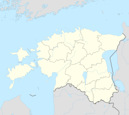
(c) Karte: NordNordWest, Lizenz: Creative Commons by-sa-3.0 de Läge i Estland. | |
Läge i Jõgevamaa. | |
Pikknurme är en by (estniska: küla) i Põltsamaa kommun i landskapet Jõgevamaa i östra Estland. Byn ligger där Riksväg 2 mellan Tallinn och Tartu korsar ån Pikknurme jõgi.
I kyrkligt hänseende hör byn till Kursi församling inom den Estniska evangelisk-lutherska kyrkan.[5]
Före kommunreformen 2017 hörde byn till dåvarande Puurmani kommun.
Källor
- ^ mois.ee
- ^ [a b c] pub.stat.ee
- ^ postiindeks.ee
- ^ http://geoportaal.maaamet.ee
- ^ ”eelk.ee”. Arkiverad från originalet den 14 april 2016. https://web.archive.org/web/20160414035348/http://eelk.ee/kihelkonnad_kaart.php. Läst 2 januari 2018.
Media som används på denna webbplats
(c) Karte: NordNordWest, Lizenz: Creative Commons by-sa-3.0 de
Location map of Estonia
Shiny red button/marker widget. Used to mark the location of something such as a tourist attraction.
Författare/Upphovsman: Nzeemin, Licens: CC BY-SA 2.0
Outline map of Jõgeva County, Estonia.


