Borough of Pendle
| Borough of Pendle | |
| Pendle District | |
| Distrikt | |
(c) John Tomlinson, CC BY-SA 2.0 | |
| Land | |
|---|---|
| Riksdel | England |
| Region | Nordvästra England |
| Ceremoniellt grevskap | Lancashire |
| Administrativt grevskap | Lancashire |
| Koordinater | 53°53′N 2°11′V / 53.88°N 2.19°V |
| Administrativ huvudort | Nelson |
| Area | 169 km²[1] |
| Folkmängd | 96 110 (2022)[2] |
| Befolkningstäthet | 569 invånare/km² |
| Tidszon | UTC (UTC+0) |
| - sommartid | BST (UTC+1) |
| GSS-kod | E07000122 |
| Geonames | 7290580 |
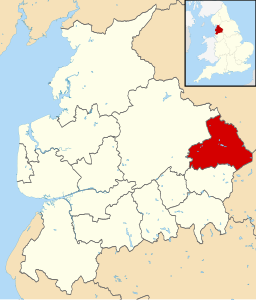
Contains Ordnance Survey data © Crown copyright and database right, CC BY-SA 3.0 Läge i Lancashire | |
Borough of Pendle är ett distrikt (motsvarande kommun) i grevskapet Lancashire i England, Storbritannien. Distriktet har 96 110 invånare (2022)[2]. Större orter är Barnoldswick, Brierfield, Colne och Nelson. Distriktet är indelat i 18 civil parishes.
Källor
- ^ ”Estimates of the population for the UK, England, Wales, Scotland, and Northern Ireland (Mid-2022)” (på engelska) (xls). Landyta, avrundad till hela km². Office for National Statistics. 26 mars 2024. https://www.ons.gov.uk/peoplepopulationandcommunity/populationandmigration/populationestimates/datasets/populationestimatesforukenglandandwalesscotlandandnorthernireland. Läst 25 juni 2024.
- ^ [a b] ”Estimates of the population for the UK, England, Wales, Scotland, and Northern Ireland (Mid-2022)” (på engelska) (xls). Office for National Statistics. 26 mars 2024. https://www.ons.gov.uk/peoplepopulationandcommunity/populationandmigration/populationestimates/datasets/populationestimatesforukenglandandwalesscotlandandnorthernireland. Läst 25 juni 2024.
| ||||||||||
Media som används på denna webbplats
Contains Ordnance Survey data © Crown copyright and database right, CC BY-SA 3.0
Map of Lancashire, UK with Pendle highlighted.
Equirectangular map projection on WGS 84 datum, with N/S stretched 165%(c) John Tomlinson, CC BY-SA 2.0
Colne Town Centre. Since 1972 this building has been used by the Providence Independent Methodists as their place of worship. It was originally built in 1869 for Nicholas England, a local cotton manufacturer. In 1907 it was converted and became a Carnegie Public Library. It typifies some of the fine buildings in Colne that show its cotton manufacturing background. To the left of this picture is a memorial to Wallace Henry Hartley who was born in Colne on 2nd June 1878. He was the bandmaster on the Titanic.


