Pauls Valley
| Pauls Valley | |
| city | |
Garvin Countys domstolsbyggnad i Pauls Valley. | |
| Land | |
|---|---|
| Delstat | Oklahoma |
| County | Garvin County |
| Höjdläge | 266 m ö.h. |
| Koordinater | 34°44′29″N 97°13′14″V / 34.74139°N 97.22056°V |
| Yta | 21,9 km² (2010) |
| - land | 21,6 km² |
| - vatten | 0,3 km² |
| Folkmängd | 6 187 (2010) |
| Befolkningstäthet | 286 invånare/km² |
| Tidszon | CST (UTC-6) |
| - sommartid | CDT (UTC-5) |
| ZIP-kod | 73075 |
| FIPS | 4057550 |
| Geonames | 4547690 |
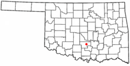
Ortens läge i Oklahoma | |
Oklahomas läge i USA | |
| Webbplats: http://paulsvalley.com/ | |
Pauls Valley är administrativ huvudort i Garvin County i Oklahoma.[1] Orten har fått sitt namn efter bosättaren Smith Paul.[2] Enligt 2010 års folkräkning hade Pauls Valley 6 187 invånare.[3]
Källor
- ^ Oklahoma County Map with County Seat Cities. Geology.com Geoscience News and Information. Läst 22 augusti 2016.
- ^ Profile for Pauls Valley, Oklahoma Arkiverad 29 augusti 2016 hämtat från the Wayback Machine.. ePodunk. Läst 22 augusti 2016.
- ^ 2010 Census Population of Pauls Valley, Oklahoma Arkiverad 28 augusti 2016 hämtat från the Wayback Machine.. Census Viewer. Läst 22 augusti 2016.
|
Media som används på denna webbplats
Författare/Upphovsman: The original uploader was Seth Ilys på engelska Wikipedia., Licens: CC BY-SA 3.0
Adapted from Wikipedia's OK county maps by Seth Ilys.
Författare/Upphovsman: This version: uploader
Base versions this one is derived from: originally created by en:User:Wapcaplet, Licens: CC BY 2.0
Map of USA with Oklahoma highlighted
Författare/Upphovsman: Crimsonedge34, Licens: CC BY-SA 3.0
Garvin County Courthouse


