Passaic County
| Passaic County | |
| County | |
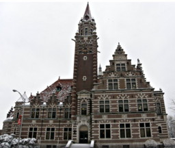
Passaic Countys domstolshus i Paterson. | |
| Land | |
|---|---|
| Delstat | |
| Huvudort | Paterson |
| Största stad | Paterson |
| Area | 510 km² (2010)[1] |
| - land | 478 km² (94%) |
| - vatten | 32,4 km² (6%) |
| Folkmängd | 501 226 (2010)[2] |
| Befolkningstäthet | 1 049 invånare/km² |
| Grundat | 1837 |
| Tidszon | EST (UTC-5) |
| - sommartid | EDT (UTC-4) |
| FIPS-kod | 34031 |
| Geonames | 5102445 |
Läge i delstaten New Jersey. | |
Delstatens läge i USA. | |
Passaic County (amerikanskt uttal: [pəˈseɪ.ᵻk], lokalt även [pəˈseɪk]) är ett administrativt område i delstaten New Jersey, USA. Passaic är ett av 21 countyn i delstaten och ligger i den norra delen av New Jersey, samt i västra delen av New Yorks storstadsregion. Vid 2010 års folkräkning hade Passaic County 501 226 invånare. Den administrativa huvudorten (county seat) och största staden är Paterson, med 146 199 invånare 2010.
Geografi
Enligt United States Census Bureau har countyt en total area på 510 km². 480 km² av den arean är land och 30 km² är vatten.
Angränsande countyn
- Orange County, New York - nord
- Rockland County, New York - nordöst
- Bergen County, New Jersey - öst
- Essex County, New Jersey - syd
- Morris County, New Jersey - sydväst
- Sussex County, New Jersey - väst
Orter och kommuner
Passaic County indelas i följande primärkommuner, med data från 2010 års federala folkräkning:[3] Andra orter som inte har självständig kommunstatus listas som del av sin kommun, de flesta definierade som census-designated places inom ett township.
| Kommun | Kommuntyp | Befolkning | Antal hushåll | Total yta (sq. miles) | Vatten | Land | Befolknings- täthet | Hushålls- täthet | Ingående orter |
|---|---|---|---|---|---|---|---|---|---|
| Bloomingdale | borough | 7 656 | 3 089 | 9,17 | 0,45 | 8,71 | 878,6 | 354,5 | |
| Clifton | city | 84 136 | 31 946 | 11,40 | 0,14 | 11,26 | 7 472,0 | 2 837,1 | |
| Haledon | borough | 8 318 | 2 932 | 1,16 | 0,00 | 1,15 | 7 203,9 | 2 539,3 | |
| Hawthorne | borough | 18 791 | 7 756 | 3,36 | 0,03 | 3,33 | 5 635,3 | 2 326,0 | |
| Little Falls | township | 14 432 | 4 925 | 2,81 | 0,07 | 2,74 | 5 276,2 | 1 800,5 | Great Notch Singac (3 618) |
| North Haledon | borough | 8 417 | 3 213 | 3,50 | 0,04 | 3,45 | 2 436,8 | 930,2 | |
| Passaic | city | 69 781 | 20 432 | 3,24 | 0,10 | 3,15 | 22 179,6 | 6 494,2 | |
| Paterson | city | 146 199 | 47 946 | 8,70 | 0,28 | 8,43 | 17 346,3 | 5 688,7 | |
| Pompton Lakes | borough | 11 097 | 4 341 | 3,19 | 0,28 | 2,91 | 3 809,1 | 1 490,1 | |
| Prospect Park | borough | 5 865 | 1 931 | 0,48 | 0,00 | 0,48 | 12 347,2 | 4 065,2 | |
| Ringwood | borough | 12 228 | 4 331 | 28,17 | 2,96 | 25,21 | 485,0 | 171,8 | |
| Totowa | borough | 10 804 | 3 918 | 4,07 | 0,07 | 3,99 | 2 704,9 | 980,9 | |
| Wanaque | borough | 11 116 | 4 184 | 9,25 | 1,26 | 7,99 | 1 391,2 | 523,7 | Haskell |
| Wayne | township | 54 717 | 19 768 | 25,17 | 1,45 | 23,73 | 2 306,0 | 833,1 | Packanack Lake Pines Lake Preakness |
| West Milford | township | 25 850 | 10 419 | 80,32 | 5,23 | 75,09 | 344,3 | 138,8 | Cooper Hewitt Macopin Newfoundland Oak Ridge |
| Woodland Park | borough | 11 819 | 4 835 | 3,11 | 0,15 | 2,96 | 3 987.9 | 1 631.4 | (tidigare West Paterson) |
| Totalt | 501 226 | 175 966 | 197,11 | 12,51 | 184,59 | 2 715,3 | 953,3 |
Källor
- Den här artikeln är helt eller delvis baserad på material från engelskspråkiga Wikipedia, Passaic County, New Jersey, 7 februari 2017.
- ^ ”2010 Census U.S. Gazetteer Files for Counties”. U.S. Census Bureau. Arkiverad från originalet den 5 juli 2012. https://www.webcitation.org/68vYLbou5?url=http://www.census.gov/geo/www/gazetteer/files/Gaz_counties_national.txt. Läst 5 juli 2012.
- ^ ”State & County QuickFacts, Passaic County, New Jersey” (på engelska). U.S. Census Bureau. Arkiverad från originalet den 16 juli 2011. https://www.webcitation.org/60E4FGqHp?url=http://quickfacts.census.gov/qfd/states/34/34031.html. Läst 6 juli 2011.
- ^ GCT-PH1: Population, Housing Units, Area, and Density: 2010 - County -- County Subdivision and Place from the 2010 Census Summary File 1 for Passaic County, New Jersey, United States Census Bureau. Läst 19 januari 2014.
| ||||||||||
|
Media som används på denna webbplats
Författare/Upphovsman: Hudconja, Licens: CC BY-SA 4.0
Old Passaic County Court House Annex (1937) originally built as US Post Office (1898) in Paterson, New Jersey by Fred Wesley Wentworth
This is a locator map showing Passaic County in New Jersey. For more information, see Commons:United States county locator maps.
Författare/Upphovsman: This version: uploader
Base versions this one is derived from: originally created by en:User:Wapcaplet, Licens: CC BY 2.0
Map of USA with New Jersey highlighted
Passaic County, New Jersey outline map of municipalities, labeled. Sources:
- NJDEP publishes Arcview shape format outline maps of counties and municpalities. Believed ((PD-ineligible)). [1]
- Converted to SVG, edited in inkscape
- Labeled according to [2]


