Paso Socompa
| Paso Socompa | |
| Portezuelo de Socompa | |
| Bergspass | |
| Länder | |
|---|---|
| Region | Región de Antofagasta |
| Provins | Provincia de Antofagasta |
| Höjdläge | 3 858 m ö.h. |
| Koordinater | 24°27′05″S 68°17′23″V / 24.45151°S 68.28966°V |
| Tidszon | BRT (UTC-3) |
| - sommartid | EDT (UTC-4) |
| Geonames | 3870760 |
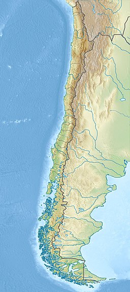
Paso Socompa är ett bergspass i Chile, på gränsen till Argentina. Paso Socompa ligger 3 858 meter över havet i Anderna.[1]
Trakten runt Paso Socompa är ofruktbar med lite eller ingen växtlighet.[2]
Källor
- ^ ”Gebirgspässe” (på tyska). Schlag nach!: 100000 Tatsachen aus allen Wissensgebieten. Fachrekationen des Bibliographischen Instituts & Springer-Verlag. 2012. sid. 532
- ^ ”NASA Earth Observations: Land Cover Classification”. NASA/MODIS. Arkiverad från originalet den 28 februari 2016. https://web.archive.org/web/20160228161657/http://neo.sci.gsfc.nasa.gov/view.php?datasetId=MCD12C1_T1. Läst 30 januari 2016.
Media som används på denna webbplats
Det är enkelt att lägga till en ram runt den här bilden
Författare/Upphovsman:
- Chile_location_map.svg: NordNordWest
- derivative work: Виктор В (talk)
Location map of Chile
Shiny red button/marker widget. Used to mark the location of something such as a tourist attraction.


