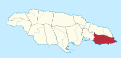
Parish of Saint Thomas
| Den här artikeln har skapats av Lsjbot, ett program (en robot) för automatisk redigering. (2016-10) Artikeln kan innehålla fakta- eller språkfel, eller ett märkligt urval av fakta, källor eller bilder. Mallen kan avlägsnas efter en kontroll av innehållet (vidare information) |
| Parish of Saint Thomas | |
| Saint Thomas, Saint Thomas Parish | |
| Parish | |
| Land | |
|---|---|
| Höjdläge | 31 m ö.h. |
| Koordinater | 17°54′00″N 76°26′00″V / 17.9°N 76.43333°V |
| Area | 742,80 km² |
| Folkmängd | 93 328 (2016-09-02)[1] |
| Befolkningstäthet | 126 invånare/km² |
| Tidszon | EST (UTC-5) |
| ISO 3166-2-kod | JM-03- |
| Geonames | 3488688 |
Läge i Jamaica | |
Parish of Saint Thomas är en parish i Jamaica.[1] Den ligger i den östra delen av landet, 40 km öster om huvudstaden Kingston. Antalet invånare är 93 328.[1] Arean är 743 kvadratkilometer.
Följande samhällen finns i Parish of Saint Thomas:
- Morant Bay
- Yallahs
- Seaforth
- Golden Grove
- Dalvey
- Trinity Ville
- Easington
- Bath
Källor
- ^ [a b c] Saint Thomas hos Geonames.org (cc-by); post uppdaterad 2016-09-02; databasdump nerladdad 2016-09-13
Externa länkar
 Wikimedia Commons har media som rör Parish of Saint Thomas.
Media som används på denna webbplats
Robot icon
Flag of Jamaica. “The sunshine, the land is green, and the people are strong and bold” is the symbolism of the colours of the flag. GOLD represents the natural wealth and beauty of sunlight; GREEN represents hope and agricultural resources; BLACK represents the strength and creativity of the people. The original symbolism, however, was "Hardships there are, but the land is green, and the sun shineth", where BLACK represented the hardships being faced.
Shiny red button/marker widget. Used to mark the location of something such as a tourist attraction.
Författare/Upphovsman: TUBS
Location of parish xy (see filename) in Jamaica.
Författare/Upphovsman: Carport, Licens: CC BY-SA 3.0
Physical location map of Jamaica


