Parish of Saint Mary (parish i Jamaica)
| Den här artikeln har skapats av Lsjbot, ett program (en robot) för automatisk redigering. (2016-10) Artikeln kan innehålla fakta- eller språkfel, eller ett märkligt urval av fakta, källor eller bilder. Mallen kan avlägsnas efter en kontroll av innehållet (vidare information) |
| Parish of Saint Mary | |
| Saint Mary, Saint Mary Parish | |
| Parish | |
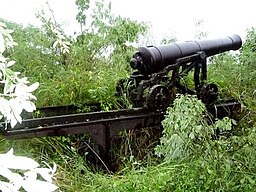
Kanon vid Fort Haldane. | |
| Land | |
|---|---|
| Höjdläge | 118 m ö.h. |
| Koordinater | 18°19′00″N 76°54′00″V / 18.31667°N 76.9°V |
| Area | 610,00 km² |
| Folkmängd | 111 377 (2016-09-02)[1] |
| Befolkningstäthet | 183 invånare/km² |
| Tidszon | EST (UTC-5) |
| ISO 3166-2-kod | JM-05- |
| Geonames | 3488693 |
Läge i Jamaica | |
Parish of Saint Mary är en parish i Jamaica.[1] Den ligger i den östra delen av landet, 40 km norr om huvudstaden Kingston. Antalet invånare är 111 377.[1] Arean är 610 kvadratkilometer. Parish of Saint Mary ligger på ön Jamaica.[a]
Terrängen i Parish of Saint Mary är varierad.[b]
Följande samhällen finns i Parish of Saint Mary:
Kommentarer
Källor
- ^ [a b c] Saint Mary hos Geonames.org (cc-by); post uppdaterad 2016-09-02; databasdump nerladdad 2016-09-13
- ^ [a b] ”Viewfinder Panoramas Digital elevation Model”. http://www.viewfinderpanoramas.org/dem3.html. Läst 21 juni 2015.
Externa länkar
 Wikimedia Commons har media som rör Parish of Saint Mary.
Media som används på denna webbplats
Robot icon
Flag of Jamaica. “The sunshine, the land is green, and the people are strong and bold” is the symbolism of the colours of the flag. GOLD represents the natural wealth and beauty of sunlight; GREEN represents hope and agricultural resources; BLACK represents the strength and creativity of the people. The original symbolism, however, was "Hardships there are, but the land is green, and the sun shineth", where BLACK represented the hardships being faced.
Shiny red button/marker widget. Used to mark the location of something such as a tourist attraction.
Författare/Upphovsman: TUBS
Location of parish xy (see filename) in Jamaica.
Författare/Upphovsman: Carport, Licens: CC BY-SA 3.0
Physical location map of Jamaica
Författare/Upphovsman: Banjoman1, Licens: CC BY-SA 3.0
This is a photo of a cannon located at Fort Haldane, Jamaica. I took this picture myself, using my own camera.


