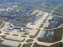
Paris-Orly flygplats
| Paris-Orly flygplats Aéroport de Paris - Orly Paris Orly Airport | |||||||||||||||||||
 | |||||||||||||||||||
| Allmän information | |||||||||||||||||||
|---|---|---|---|---|---|---|---|---|---|---|---|---|---|---|---|---|---|---|---|
| Ort | Paris | ||||||||||||||||||
| Flygplatstyp | Internationell flygplats | ||||||||||||||||||
| IATA-kod | ORY | ||||||||||||||||||
| ICAO-kod | LFPO | ||||||||||||||||||
| Driftbolag | Aéroports de Paris | ||||||||||||||||||
| Höjd över havet | 89 meter | ||||||||||||||||||
| Koordinater | 48°43′33″N 2°22′0″Ö / 48.72583°N 2.36667°Ö | ||||||||||||||||||
| Banor | |||||||||||||||||||
| |||||||||||||||||||
| Statistik | |||||||||||||||||||
| Passagerare (2023) | 32,294,167 | ||||||||||||||||||
| ||||
 | ||||
| Stationsinformation | ||||
|---|---|---|---|---|
| Stad | Paris, Frankrike | |||
| Ingång från | Aéroport d'Orly | |||
| Invigd | 2024 | |||
| Kapacitet | ||||
| Antal plattformar | 2 st | |||
| Förbindelser | ||||
| Linje | ||||
Paris-Orly flygplats (franska: Aéroport de Paris–Orly) (IATA: ORY, ICAO: LFPO) är en internationell flygplats i Orly, 14[1] kilometer söder om Paris i Frankrike. Den var Paris huvudflygplats innan den internationella flygplatsen Paris-Charles de Gaulle flygplats byggdes 1974[1].
Flygplatsen har fyra terminaler fördelade på Terminal 1,2 (fd Orly Väst), Terminal 3 och Terminal 4 (fd Orly Syd).
Från flygplatsen går Paris tunnelbana linje 14 direkt till centrala Paris och Châtelet. Vidare finns linjer med byten såsom Paris spårvägar linje 7 till metrostation Villejuif–Louis Aragon, där man kan åka mot centrala staden. Orlyval går till RER-linje B, och RER-tåget går sedan vidare mot centrala staden.
- Terminal 1,2,3,4
- Terminal 1,2
- Terminal 3
- Terminal 4
- Paris-Orly flygplats
- Orly Syd
- Spårvagn på linje 7 Aéroport d'Orly
- Orlyvaltåg på Aéroport d'Orly
Statistik
Sökfråga på wikidata efter rådata.
Referenser
- ^ [a b] ”Orly Airport”. www.ne.se. https://www.ne.se/uppslagsverk/encyklopedi/l%C3%A5ng/orly-airport. Läst 23 januari 2020.
Externa länkar
 Wikimedia Commons har media som rör Paris-Orly flygplats.
| |||||||
| ||||||||
|
Media som används på denna webbplats
Författare/Upphovsman: Eric Gaba (Sting - fr:Sting), Licens: CC BY-SA 4.0
Blank physical map of metropolitan France for geo-location purpose.
Scale : 1:14 816 000 (accuracy : about 3,7 km) for the bathymetry. More maps of France, view → Commons Atlas of France.
Icon-type silhouette of an airplane. (Mainly to be used in Userboxes)
Paris Metro logo
Författare/Upphovsman: Muhammad ECTOR Prasetyo, Licens: CC BY 2.0
Paris-Orly Airport
Författare/Upphovsman: Clicsouris, Licens: CC BY-SA 2.5
Orlyval, station départs Orly-Sud
Vue sur les toits de Orly sud, et sur les parkings avions. on peut voir le B747 FG-SUN, reconnaissable à un soleil peint sur son fuselage
Map symbol used by the U.S. National Park Service to indicate an airport
Författare/Upphovsman: Chabe01, Licens: CC BY-SA 4.0
Station Aéroport d'Orly de la ligne 14 du métro de Paris, Paray-Vieille-Poste.
Författare/Upphovsman: Cramos, Licens: CC BY-SA 3.0
Rame Citadis de la ligne 7 du tramway d'Île-de-France, entre les arrêts Cœur d'Orly et Aéroport d'Orly.
Transit icon for Line 14 of the Paris Métro. See {{Paris transit icons}} for colour standards.
- own work
- line-art inspired by contemporary metro plans
Författare/Upphovsman: Sofiane Haddi, Licens: CC BY-SA 4.0
Diagram of new names (as of April 2019) for Orly Airport terminals
Författare/Upphovsman: Captainm, Licens: CC BY-SA 3.0
Orly Airport, West Terminal, Air France - La Navette Hall
Författare/Upphovsman: Bair175, Licens: CC BY-SA 4.0
The South Terminal at Orly Airport, outside Paris, France. Hundres of photographs of people and the word Bienvenue (Welcome) covers the facade.
Författare/Upphovsman: Chabe01, Licens: CC BY-SA 4.0
Terminal 3 de l'aéroport d'Orly, Paray-Vieille-Poste.


