Palombaro
| Palombaro | |
| Kommun | |
| Officiellt namn: Comune di Palombaro | |
| Land | |
|---|---|
| Region | Abruzzo |
| Provins | Chieti |
| Höjdläge | 536 m ö.h. |
| Koordinater | 42°07′29″N 14°13′50″Ö / 42.12484°N 14.23061°Ö |
| Yta | 17,19 km²[1] |
| Folkmängd | 991 (2018)[2] |
| Befolkningstäthet | 58 invånare/km² |
| Tidszon | CET (UTC+1) |
| - sommartid | CEST (UTC+2) |
| Postnummer | 66010 |
| Riktnummer | (+39) 0871 |
| ISTAT-kod | 069062 |
| Geonames | 6540016 |
Kommunens läge i Italien | |
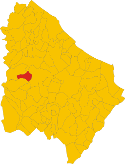
Kommunens läge i Chieti | |
| Webbplats: Palombaro | |
Palombaro är en ort och kommun i provinsen Chieti i regionen Abruzzo i Italien. Kommunen hade 991 invånare (2018).[2]
Referenser
- ^ ”Territorial features, Total area (Engelska)”. Istituto Nazionale di Statistica. 2019. http://dati.istat.it/. Läst 3 oktober 2019.
- ^ [a b] ”Statistiche demografiche ISTAT”. demo.istat.it. Arkiverad från originalet den 14 januari 2018. https://web.archive.org/web/20180114115045/http://demo.istat.it/bilmens2018gen/index.html. Läst 3 oktober 2019.
Media som används på denna webbplats
Författare/Upphovsman: Eric Gaba (Sting - fr:Sting) and NordNordWest, Licens: CC BY-SA 3.0
Blank physical map of Italy including the 08-2009 modification of the boundary between Emilia-Romagna and Marche regions, for geo-location purpose.
Shiny red button/marker widget. Used to mark the location of something such as a tourist attraction.
Map of the Provincia of Chieti.
Map of the municipality (comune) of Palombaro (province of Chieti, region Abruzzo, Italien)
Författare/Upphovsman: Zitumassin, Licens: CC BY-SA 3.0
Panoramica della chiesa madre di Palombaro, Chieti.


