Oxfordshire
| Oxfordshire | ||
| Ceremoniellt och administrativt grevskap | ||
| ||
| Motto: Sapere Aude ("Våga veta") | ||
| Land | ||
|---|---|---|
| Riksdel | England | |
| Region | Sydöstra England | |
| Ingående distrikt | Oxford, Cherwell, South Oxfordshire, Vale of White Horse, West Oxfordshire | |
| Administrativ huvudort | Oxford | |
| Yta | 2 605 km²[1] | |
| Folkmängd | 738 276 (2022)[2] | |
| Befolkningstäthet | 283 invånare/km² | |
| Tidszon | GMT (UTC+0) | |
| - sommartid | BST (UTC+1) | |
| GSS-kod | E10000025 | |
| Geonames | 2640726 11609045 | |
Oxfordshire är ett ceremoniellt och administrativt grevskap (county), beläget i södra England mellan London i sydöst och Birmingham i nordväst. Administrativ huvudort är universitetsstaden Oxford. Befolkningen uppgick till 738 276 personer i mitten av 2022[2].
Oxfordshires landskap karakteriseras av böljande kullar. Kullarna Chiltern Hills återfinns i östra delen av grevskapet och delas med angränsande Buckinghamshire. I söder utgör floden Themsen gräns mot Berkshire. Themsen leder upp till Oxford och möter här Oxfordshires andra större flod, Cherwell. Runt Oxford kallas dock Themsen enligt urgammal tradition för Isis. Västra delen av grevskapet utgörs av natursköna Cotswolds, som fortsätter vidare in i Gloucestershire.
Några andra städer i grevskapet är Abingdon, Didcot, Wallingford, Henley-on-Thames, Banbury och Bicester.
Administrativ indelning
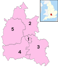
Oxfordshire är dels ett ceremoniellt grevskap (ceremonial county), dels ett administrativt grevskap som är en typ av sekundärkommun (non-metropolitan county). Det administrativa grevskapet är indelat i fem distrikt (non-metropolitan districts), som är en typ av primärkommun.
Oxfordshires historia som grevskap går tillbaka till 900-talet. Oxfordshire County Council är idag det lokala politiska organ som administrerar området, vilket med undantag för några gränsförändringar under 1970-talet huvudsakligen överensstämmer med det historiska grevskapet Oxfordshire.
| Nr | Distrikt | Distrikten i Oxfordshire |
|---|---|---|
| 1 | Oxford | |
| 2 | Cherwell | |
| 3 | South Oxfordshire | |
| 4 | Vale of White Horse | |
| 5 | West Oxfordshire |
Några sevärdheter
- Blenheim Palace, 1700-talsslott (ett av Englands största slott) vid Woodstock nordväst om Oxford.
- Området Cotswolds i väster med lockande natur och vackra byar.
- Oxford med dess universitet.
- Inspelningsplats för flera filmer och tv-serier. Bland annat filmer som Godnatt, mister Tom, Chitty Chitty Bang Bang och tv-serier som Morden i Midsomer och Ett herrans liv.
Källor
- ^ ”Estimates of the population for the UK, England, Wales, Scotland, and Northern Ireland (Mid-2022)” (på engelska) (xls). Landyta, avrundad till hela km². Office for National Statistics. 26 mars 2024. https://www.ons.gov.uk/peoplepopulationandcommunity/populationandmigration/populationestimates/datasets/populationestimatesforukenglandandwalesscotlandandnorthernireland. Läst 25 juni 2024.
- ^ [a b] ”Estimates of the population for the UK, England, Wales, Scotland, and Northern Ireland (Mid-2022)” (på engelska) (xls). Office for National Statistics. 26 mars 2024. https://www.ons.gov.uk/peoplepopulationandcommunity/populationandmigration/populationestimates/datasets/populationestimatesforukenglandandwalesscotlandandnorthernireland. Läst 25 juni 2024.
Media som används på denna webbplats
Författare/Upphovsman: JimmyGuano, Licens: CC0
The County Flag of the County of Oxfordshire, as flown at County Hall in Oxford. Own work, based on evidence of its design from the following sources: [1] and [2] and the following to verify that it is indeed the official flag flown alongside the Union Jack at County Hall: [3], [4]
(c) Nilfanion, CC BY 3.0
Numbered districts of Oxfordshire county. Derived from File:Oxfordshire UK district map (blank).svg, by Nilfanion.
(c) Pam Brophy, CC BY-SA 2.0
The Manger on a Summer's Evening. This square is of historical and geographical value and the land managed by the national trust. The square contains this interesting hill structure and is the western part of "The Manger", Dragon Hill being on the eastern side. Uffington Castle fort is contained mostly in this square with about a third of it in the next adjacent square. This view of the manager was taken from the vicinity of the white horse in the adjacent square, looking more or less north west.
Författare/Upphovsman: Nilfanion, Licens: CC BY-SA 3.0
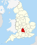
Location of the ceremonial county of Oxfordshire within England.
Författare/Upphovsman:
- File:Oxford Skyline Panorama from St Mary's Church - Oct 2006.jpg → User:Diliff
- File:Radcliffe Camera → User:Diliff
- File:High Street from above looking east.JPG → User:Ozeye
- File:University College Oxford.jpg → User:1970gemini
- File:High Street in Oxford by Night 2009 LL.jpg → User:Lionelleo
- File:Natural History Museum and Pitt River Museum.jpg → User:Ha!
The purpose of this picture is for people to get an at-glance look at some of the key landmarks of Oxford.
From top left to bottom right:
- Oxford Skyline Panorama from St Mary's Church
- Radcliffe Camera
- High Street from Above Looking East
- University College Oxford
- High Street in Oxford by Night
- Natural History Museum and Pitt River Museum


