Ouistreham
| Ouistreham | ||
| Kommun | ||
 | ||
| ||
| Land | ||
|---|---|---|
| Region | ||
| Departement | ||
| Arrondissement | Caen | |
| Kanton | Ouistreham | |
| Koordinater | 49°17′N 0°15′V / 49.283°N 0.250°V | |
| Yta | 9,95 km²[1] | |
| Folkmängd | 9 331 ()[2] | |
| Befolkningstäthet | 938 invånare/km² | |
| Tidszon | CET (UTC+1) | |
| - sommartid | CEST (UTC+2) | |
| Postnummer | 14150 | |
| INSEE | 14488 | |
| Geonames | 2989013 | |
| OSM-karta | 145717 | |
 Kommunens läge i regionen Normandie i Frankrike | ||
| Webbplats: https://ouistreham-rivabella.fr/ | ||


Ouistreham är en kommun i departementet Calvados i regionen Normandie i nordvästra Frankrike. Kommunen ligger i kantonen Ouistreham som ligger i arrondissementet Caen. År 2021 hade Ouistreham 9 331 invånare.
Ouistreham fungerar som staden Caens hamn och har färjeförbindelse med brittiska Portsmouth.
De enda franska trupperna delaktiga i D-dagen landsteg i Ouistreham den 6 juni 1944.
Befolkningsutveckling
Antalet invånare i kommunen Ouistreham
Referens:INSEE[3]
Galleri
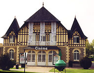 (c) I, Matmonroe, CC BY-SA 3.0
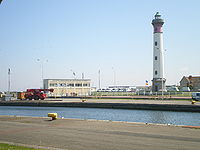

Se även
Källor
- ^ Répertoire géographique des communes, Institut national de l'information géographique et forestière, läst: 26 oktober 2015, licens: öppen licens.[källa från Wikidata]
- ^ Populations légales 2021, Institut National de la Statistique et des Études Économiques, 28 december 2023.[källa från Wikidata]
- ^ Chiffres clés - Évolution et structure de la population Arkiverad 5 juli 2012 hämtat från the Wayback Machine.
Externa länkar
Media som används på denna webbplats

Författare/Upphovsman: Eric Gaba (Sting - fr:Sting), Licens: CC BY-SA 4.0
Blank physical map of metropolitan France for geo-location purpose.
Scale : 1:14 816 000 (accuracy : about 3,7 km) for the bathymetry. More maps of France, view → Commons Atlas of France.

Shiny red button/marker widget. Used to mark the location of something such as a tourist attraction.
Författare/Upphovsman:
|
Map data (c) OpenStreetMap contributors, CC-BY-SA _French_municipality_map.svg) • Shape files infrastructure: railway, highways, water: all originally by OpenStreetMap contributors. Status december 2011 *note: shown commune boundaries are from OSM dump May 2012; at that time about 90% complete |
Map commune FR insee code 14488.png
.svg)
Författare/Upphovsman: Den här vektorbilden skapades med Inkscape av v ., Licens: CC BY-SA 3.0
Gules, two lions passant guardant in pale or armed and langued azure, used as the inofficial "coat of arms of Normandy".
Coat of arms attributed to "Arms of William the Conqueror (William I of England)"

Författare/Upphovsman: Roi.dagobert, Licens: CC BY-SA 3.0
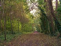
Le Chemin des pèlerins, ancienne voie romaine dans le Bois du Caprice, classé espace naturel sensible, sur les communes de Ouistreham, Saint-Aubin-d'Arquenay et Colleville-Montgomery

Författare/Upphovsman: Original uploader was Cevenol2 at fr.wikipedia, Licens: CC BY-SA 2.0 fr
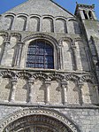
église de Ouistreham dans le Calvados en fr:France. Cette église a été construite entre le XIIème et le XIIIème siècle


Phare de Ouistreham, vu du terre-plein de l'écluse.

Des chalutiers du port de Ouistreham.
La capitainerie du port de Ouistreham dans le Calvados.