Otaru
| Otaru (小樽市) | |
| Stad | |
| Land | |
|---|---|
| Prefektur | Hokkaido |
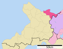
| Subprefektur | Shiribeshi |
| Ö | Hokkaido |
| Koordinater | 43°11′N 141°0′Ö / 43.183°N 141.000°Ö |
| Area | 243,83 km²[1] |
| Folkmängd | 107 393 (1 oktober 2022)[1] |
| Befolkningstäthet | 440 invånare/km² |
| Borgmästare | Toshiya Hazama (2018–) |
| Geonames | 2128570 |
| Träd | Glasbjörk[2] |
| Fågel | Vitbukig grönduva[2] |
| Blomma | Azalea[2] |
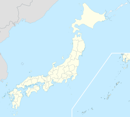
 Otarus läge i Japan | |
 Signifikanta städer Övriga städer Landskommuner | |
| Webbplats: http://www.city.otaru.hokkaido.jp | |
Otaru(japanska: 小樽市?, Otaru-shi) är en hamnstad på den japanska ön Hokkaido. Otaru ligger i Shiribeshi subprefektur och har cirka 107 000 invånare (2022). Staden ingår i Sapporos storstadsområde.[3]

Borgmästare
- Kazuo Shimura, 30 april 1975–29 april 1987
- Masa'aki Araya, 30 april 1987–29 april 1999
- Katsumaro Yamada, 30 april 1999–29 april 2011
- Yoshiharu Nakamatsu, 30 april 2011–29 april 2015
- Hideaki Morii, 30 april 2015–25 juli 2018
- Toshiya Hazama, 26 augusti 2018–
Denna lista hämtas från Wikidata. Informationen kan ändras där.
Källor
- ^ [a b] ”北海道の市区町村 Kommuner i Hokkaido prefektur” (på japanska). Masahiro Higashide. https://uub.jp/cty/hokkaido.html. Läst 19 augusti 2023.
- ^ [a b c] ”Profile of Otaru-shi”. Otaru stad. http://otaru.web.transer.com/bb_url_ej.php?ctw_=sT,eCR-JE,bF,hT,uaHR0cDovL3d3dy5jaXR5Lm90YXJ1Lmhva2thaWRvLmpwL3NvdW11L3NvdW11L3Byby5odG0=,f20090726064559-0,ceC1zamlz,. Läst 25 juli 2009.
- ^ Publikation 2005 Population Census of Japan, Overview Series No.9; Population of Major Metropolitan Areas, Statistics Bureau, Ministry of Internal Affairs and Communications, Japan; ISBN 978-4-8223-3577-9.
Externa länkar
 Wikimedia Commons har media som rör Otaru.
Media som används på denna webbplats
Författare/Upphovsman: Maximilian Dörrbecker (Chumwa), Licens: CC BY-SA 3.0
Location map of Japan
Equirectangular projection.
Geographic limits to locate objects in the main map with the main islands:
- N: 45°51'37" N (45.86°N)
- S: 30°01'13" N (30.02°N)
- W: 128°14'24" E (128.24°E)
- E: 149°16'13" E (149.27°E)
Geographic limits to locate objects in the side map with the Ryukyu Islands:
- N: 39°32'25" N (39.54°N)
- S: 23°42'36" N (23.71°N)
- W: 110°25'49" E (110.43°E)
- E: 131°26'25" E (131.44°E)
Shiny red button/marker widget. Used to mark the location of something such as a tourist attraction.
A section of the skyline of Otaru, Hokkaido, Japan in August, 2006. Photograph by Causality-GT


