Urtijëi
| Urtijëi | |
| St. Ulrich Ortisei | |
| Kommun | |
Vy över Urtijëi | |
| Officiellt namn: Chemun de Urtijëi Gemeinde St. Ulrich Comune di Ortisei | |
| Land | |
|---|---|
| Region | Trentino-Sydtyrolen |
| Provins | Sydtyrolen (BZ) |
| Höjdläge | 1 234 m ö.h. |
| Koordinater | 46°34′31″N 11°40′20″Ö / 46.57528°N 11.67222°Ö |
| Yta | 24,16 km²[1] |
| Folkmängd | 4 777 (2024-01-01)[2] |
| Befolkningstäthet | 198 invånare/km² |
| Tidszon | CET (UTC+1) |
| - sommartid | CEST (UTC+2) |
| Postnummer | 39046 |
| Riktnummer | 0471 |
| ISTAT-kod | 021061 |
| Geonames | 6535976 |
| Skyddspatron | Udalricus |
| OSM-karta | 47265 |
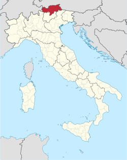
Läge i Italien | |
Kommunens läge i provinsen Sydtyrolen | |
| Webbplats: www.comune.ortisei.bz.it | |
Urtijëi (ladinskt uttal: [uʀtiˈʒɜi̯] (![]() lyssna), tyska: St. Ulrich [zaŋkt ˈʊlrɪç], italienska: Ortisei [ortiˈzɛi]) är en ort och kommun i provinsen Sydtyrolen i regionen Trentino-Sydtyrolen i norra Italien. Den gränsar till kommunerna Kastelruth, Lajen, Santa Cristina Gherdëina och Villnöß. Kommunen har 4 777 invånare (2024),[2] på en yta av 24,16 km².[1] Enligt 2024 års folkräkning talar 79,75 % av befolkningen ladinska, 10,35 % tyska och 9,90 % italienska som modersmål.[3]
lyssna), tyska: St. Ulrich [zaŋkt ˈʊlrɪç], italienska: Ortisei [ortiˈzɛi]) är en ort och kommun i provinsen Sydtyrolen i regionen Trentino-Sydtyrolen i norra Italien. Den gränsar till kommunerna Kastelruth, Lajen, Santa Cristina Gherdëina och Villnöß. Kommunen har 4 777 invånare (2024),[2] på en yta av 24,16 km².[1] Enligt 2024 års folkräkning talar 79,75 % av befolkningen ladinska, 10,35 % tyska och 9,90 % italienska som modersmål.[3]
Orter
Orter (località) i kommunen Urtijëi med fler än 20 invånare (inom parentes invånarantal 2021):[4]
- Urtijëi/St. Ulrich/Ortisei (4 402)
- Pra (58)
- Rainelles (70)
- Sacun/St. Jakob/San Giacomo (46)
Kända personer från Urtijëi
Från Urtijëi kommer discomusikproducenten Giorgio Moroder, konståkerskan Carolina Kostner, skådespelaren Luis Trenker och Ingemar Stenmarks tränare Hermann Nogler.
Referenser
- ^ [a b] ”Caratteristiche del territorio – Superfici territoriali”. esploradati.istat.it. Istituto Nazionale di Statistica (ISTAT). https://esploradati.istat.it/databrowser/#/it/dw/categories/IT1,Z0930TER,1.0/DCCV_CARGEOMOR_ST_COM/IT1,DCCV_CARGEOMOR_ST_COM,1.0. Läst 25 januari 2025.
- ^ [a b] ”Popolazione e famiglie – Popolazione residente al 1° gennaio”. esploradati.istat.it. Istituto Nazionale di Statistica (ISTAT). https://esploradati.istat.it/databrowser/#/it/dw/categories/IT1,POP,1.0/POP_POPULATION/DCIS_POPRES1. Läst 25 januari 2025.
- ^ ”Ergebnisse Sprachgruppenzählung 2024 / Risultati Censimento linguistico 2024” (på tyska & italienska) (
 PDF). astat.provinz.bz.it. Landesinstitut für Statistik (ASTAT). 6 december 2024. https://astat.provinz.bz.it/de/aktuelles-publikationen-info.asp?news_action=300&news_image_id=1160209. Läst 28 januari 2025.
 - ^ ”Basi territoriali e variabili censuarie” (på italienska). www.istat.it. Istituto Nazionale di Statistica (ISTAT). 26 juli 2024. https://www.istat.it/notizia/basi-territoriali-e-variabili-censuarie/. Läst 28 januari 2025.
Externa länkar
 Wikimedia Commons har media som rör Urtijëi.
- Officiell webbplats
Media som används på denna webbplats
Shiny red button/marker widget. Used to mark the location of something such as a tourist attraction.
Författare/Upphovsman: Sajoch, Licens: CC BY-SA 3.0
pronunciation of Urtijëi in Ladin
Författare/Upphovsman: Original: NordNordWest, from Italy Bolzano-Bozen location map.svg:
Härlett verk: Krepideia, Licens: CC BY-SA 3.0
Map of the municipality (comune) of Ortisei (province of Bolzano, region Trentino-South Tyrol, Italien)
Författare/Upphovsman: TUBS
Location of the province South Tyrol in Italy.
Författare/Upphovsman:
| Feel free to use my photos, but please mention me as the author and send me a message. |
This image is not public domain. Please respect the copyright protection. It may only be used according to the rules mentioned here. This specifically excludes use in social media, if applicable terms of the licenses listed here not appropriate.
|

| Please do not upload an updated image here without consultation with the Author. The author would like to make corrections only at his own source. This ensures that the changes are preserved.
Please if you think that any changes should be required, please inform the author. Otherwise you can upload a new image with a new name. Please use one of the templates derivative or extract. |
View of the town Urtijëi, Gröden in the Dolomites.
Författare/Upphovsman: TUBS
Location of province XY (see filename) in Italy.


