Oestrich-Winkel
| Oestrich-Winkel | ||
| Stad | ||
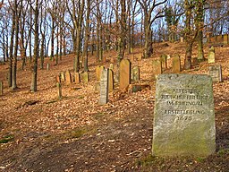
Judiska griftegården i Oestrich-Winkel. | ||
| ||
| Land | ||
|---|---|---|
| Förbundsland | Hessen | |
| Regierungsbezirk | Darmstadt | |
| Kreis | Rheingau-Taunus-Kreis | |
| Höjdläge | 84 m ö.h. | |
| Koordinater | 50°1′N 8°1′Ö / 50.017°N 8.017°Ö | |
| Yta | 59,51 km² ()[1] | |
| Folkmängd | 11 823 ()[2] | |
| Befolkningstäthet | 199 inv./km² | |
| Postnummer | 65375 | |
| Riktnummer | (+49) 06723 | |
| Kommunkod | 06 4 39 012 | |
| Regionalkod | 06 4 39 0012 06 4 39 0012 012 | |
| Geonames | 6557763 | |
| OSM-karta | 409031 | |
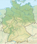
Läget för Oestrich-Winkel i Tyskland | ||
Läget för Oestrich-Winkel i Rheingau-Taunus-Kreis | ||
| Webbplats: Oestrich-Winkel | ||
Oestrich-Winkel är en stad i Rheingau-Taunus-Kreis i det tyska förbundslandet Hessen. Oestrich-Winkel har cirka 12 000 invånare.
Kommunen bildades 1 juli 1972 genom en sammanslagning av kommunerna Mittelheim, Oestrich och Winkel.[3] Hallgarten uppgick 1 januari 1977 i kommen.[4]
Ortsteile
Oestrich-Winkel har fyra distrikt: Hallgarten, Mittelheim, Oestrich och Winkel.
- Oestrich-Winkel
Referenser
- ^ Alle politisch selbständigen Gemeinden mit ausgewählten Merkmalen am 31.12.2018 (4. Quartal) (på tyska), Statistisches Bundesamt, läs online, läst: 10 mars 2019.[källa från Wikidata]
- ^ Alle politisch selbständigen Gemeinden mit ausgewählten Merkmalen am 31.12.2022, Statistisches Bundesamt, 21 september 2023, läs online, läst: 7 oktober 2023.[källa från Wikidata]
- ^ ”Gebietsänderungen vom 01.01. bis 31.12.1972” (Excel). Statistisches Bundesamt. 1972. https://www.destatis.de/DE/Themen/Laender-Regionen/Regionales/Gemeindeverzeichnis/Namens-Grenz-Aenderung/1972.html. Läst 18 november 2020.
- ^ ”Gebietsänderungen vom 01.01. bis 31.12.1977” (Excel). Statistisches Bundesamt. 1977. https://www.destatis.de/DE/Themen/Laender-Regionen/Regionales/Gemeindeverzeichnis/Namens-Grenz-Aenderung/1977.html. Läst 18 november 2020.
- Den här artikeln är helt eller delvis baserad på material från tyskspråkiga Wikipedia, Oestrich-Winkel, 29 mars 2014.
|
Media som används på denna webbplats
Författare/Upphovsman: TUBS
Location map of Germany with waterbodies
Shiny red button/marker widget. Used to mark the location of something such as a tourist attraction.
Wappen der ehemaligen Gemeinde Mittelheim bis 1972, dann Wappen der Stadt Oestrich-Winkel. Blasonierung: In Rot ein verkehrtes silbernes Z, beiderseits von einem goldenen Stern begleitet.
Författare/Upphovsman: Gerd Eichmann, Licens: CC BY-SA 4.0
Oestrich-Winkel in Rheingau-Taunus-Kreis
Författare/Upphovsman: Gerd Eichmann, Licens: CC BY-SA 4.0
Church of the Assumption of Mary at Oestrich-Winkel, district Hallgarten
Författare/Upphovsman: Gerd Eichmann, Licens: CC BY-SA 4.0
Church of Saint Martin in Oestrich-Winkel, district Oestrich
Författare/Upphovsman: Gerd Eichmann, Licens: CC BY-SA 4.0
Oestrich-Winkel, district Mittelheim
|
|
|
|
|
|
|
|
Författare/Upphovsman: Gerd Eichmann, Licens: CC BY-SA 4.0
Oestrich-Winkel, district Hallgarten
Författare/Upphovsman: Gerd Eichmann, Licens: CC BY-SA 4.0
Vollrads castle in Oestrich-Winkel
Författare/Upphovsman: Gerd Eichmann, Licens: CC BY-SA 4.0
Oestrich-Winkel, district Oestrich
Författare/Upphovsman: Gerd Eichmann, Licens: CC BY-SA 4.0
Church of St. Walburga at Oestrich-Winkel, district Winkel
Författare/Upphovsman: Gerd Eichmann, Licens: CC BY-SA 4.0
Basilica of St. Aegidius at Oestrich-Winkel, district Mittelheim
Författare/Upphovsman: Marion Halft, Licens: CC BY-SA 3.0
This is a picture of the Hessian Kulturdenkmal (cultural monument) with the ID
Författare/Upphovsman: Gerd Eichmann, Licens: CC BY-SA 4.0
Church of the Assumption of Mary at Oestrich-Winkel, district Hallgarten


