Nythe, Eldene and Liden
| Nythe, Eldene and Liden | |
| Civil parish | |
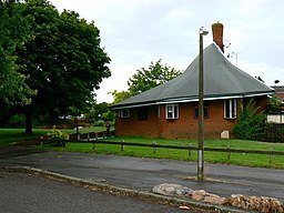
(c) Brian Robert Marshall, CC BY-SA 2.0 Eldene | |
| Land | |
|---|---|
| Riksdel | England |
| Ceremoniellt grevskap | Wiltshire |
| Enhetskommun | Swindon |
| Koordinater | 51°33′51″N 1°44′22″V / 51.5642°N 1.7395°V |
| Grundad | 1 april 2017 |
| Tidszon | UTC (UTC+0) |
| - sommartid | BST (UTC+1) |
Läge i Storbritannien | |
Nythe, Eldene and Liden är en civil parish i Swindon i Wiltshire i England.[1] Skapad 1 april 2017.[2]
Referenser
- ^ ”Nythe, Eldene and Liden”. MapIt. https://mapit.mysociety.org/area/151498.html. Läst 16 maj 2017.
- ^ The Swindon Borough (Reorganisation of Community Governance) Order 2017
Media som används på denna webbplats
Författare/Upphovsman: Alexrk2, Licens: CC BY-SA 3.0
Location map of the United Kingdom
Shiny red button/marker widget. Used to mark the location of something such as a tourist attraction.
(c) Brian Robert Marshall, CC BY-SA 2.0
The Crumpled Horn, Eldene Centre, Swindon This pub in the centre of the urban village of Eldene was built on a sloping site in the early 1970s. Gossip at the time was that the architect had designed this pub long before a site was available for it. The topography of this location met the requirements for the pub and it was duly constructed.


