Nyamata
| Nyamata | |
| Ort | |
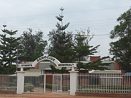
Nyamatas katolska kyrka, nu Nyamata folkmordsminnesplats. | |
| Land | |
|---|---|
| Region | Östprovinsen |
| Koordinater | 02°12′18″S 30°08′42″Ö / 2.20500°S 30.14500°Ö |
| Befolkning | 17 076 (2012) |
Nyamatas läge i Rwanda | |
Nyamata är en ort i Östprovinsen i Rwanda. Den hade 17 076 invånare år 2012.[1]
Referenser
Media som används på denna webbplats
Flag of Rwanda. The flag ratio is 2:3 with the stripes being 2:1:1. Colors are the following officially: Pantone 299 C 2X (blue), RAL 6029 (green), RAL 1023 (yellow) and RAL 1003 (golden yellow). (As of 03/08/2010, the only color used is the Pantone 299 C, which is from here. The rest of the colors are RAL shades from here.)
Shiny red button/marker widget. Used to mark the location of something such as a tourist attraction.
Författare/Upphovsman: Carport, Licens: CC BY-SA 3.0
Physical location map of Rwanda
Författare/Upphovsman: Ziqo, Licens: CC BY-SA 4.0
Nyamata Genocide Herdenkingssite


