Norfolk, Virginia
| Norfolk, Virginia | |||
| Independent city | |||
| |||
| Land | |||
|---|---|---|---|
| Delstat | Virginia | ||
| Läge | 36°50′56″N 76°10′45″V / 36.84889°N 76.17917°V | ||
| - koordinater | 36°50′56″N 76°10′45″V / 36.84889°N 76.17917°V | ||
| Yta | |||
| - total: | 249,4 km² | ||
| - varav land: | 139,2 km² | ||
| - varav vatten: | 110,2 km² | ||
| Folkmängd | 246 400 (2016) | ||
| Grundad | 1682 | ||
| FIPS | 5157000 | ||
| Geonames | 4776222 | ||
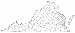
Norfolks läge på en karta över Virginia. | |||
Norfolk är en stad och ett countyfritt område (independent city)[1] i delstaten Virginia, USA med 246 000 invånare (2016).[2] I storstadsområdet ingår även städerna Newport News och Hampton, och tillsammans bor där 1,4 miljoner människor. Norfolk ligger vid Chesapeake Bays mynning i Atlanten och har en viktig handelshamn och omfattande industri.[2] I staden finns Naval Station Norfolk, världens största örlogsbas samt högkvarteren för både NATO:s atlantkommando (Allied Command Transformation, tidigare SACLANT) och USA:s atlantflotta[2].
Se även

Referenser
Noter
- ^ ”City of Norfolk Budget Book” (på engelska). City of Norfolk. https://www.norfolk.gov/DocumentCenter/View/50328/18-Norfolk-Statistical-Information?bidId=. Läst 27 juli 2022.
- ^ [a b c] ”Norfolk - Uppslagsverk - NE.se”. www.ne.se. https://www.ne.se/uppslagsverk/encyklopedi/l%C3%A5ng/norfolk-(stad-virginiausa). Läst 27 juli 2022.
Externa länkar
 Wikimedia Commons har media som rör Norfolk.
Media som används på denna webbplats
Författare/Upphovsman: The original uploader was Seth Ilys på engelska Wikipedia., Licens: CC BY-SA 3.0
Adapted from Wikipedia's VA county maps by Seth Ilys.
Författare/Upphovsman: Gabor Eszes (UED77), Licens: CC BY-SA 3.0
The panoramic skyline of en:Norfolk, Virginia, viewed from a small park on the grounds of Portsmouth Naval Hospital.
Seven pictures were taken with a Konica Minolta DiMAGE Z10 with the help of a firmly anchored tripod. Due to difference in exposure, which caused the sky and water of the first three composing pictures to be of completely different brightness, I chose to use a composite method for assembling the panorama. The right part was hand-stiched in Paint Shop Pro 8 with the help of a graphic tablet's eraser function: each picture was a separate layer, and I gradually erased with 10% opacity parts away from the edges of the pictures. The left part would've required more work with brightness correction, so I chose to resort to a semi-automatic stiching program instead, which fortunately took care of the color differences. I combined the two halves in Paint Shop Pro with the same erasing technique.Flag of Norfolk, Virginia. It was created in 1946.
Författare/Upphovsman: PghPhxNfk, Licens: CC BY-SA 3.0
Montage of images from Norfolk, Virginia, USA


