Nishinoomote
| Nishinoomote (西之表市) | |
| Stad | |
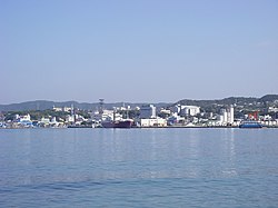
Hamnen i Nishinoomote | |
| Land | |
|---|---|
| Region | Kyūshū |
| Prefektur | Kagoshima prefektur |
| Ö | Tanegashima |
| Koordinater | 30°41′N 131°01′Ö / 30.683°N 131.017°Ö |
| Area | 205,66 km²[1] |
| Folkmängd | 15 657 (1 okt 2016)[1] |
| Befolkningstäthet | 76 invånare/km² |
| Geonames | 1855201 1855203 |
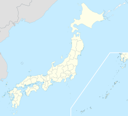
Nishinoomotes läge i Japan | |
Nishinoomotes läge i Kagoshima prefektur Städer: Signifikanta städer Övriga städer Landskommuner: Köpingar Byar | |
| Webbplats: http://www.city.nishinoomote.kagoshima.jp/ | |
Nishinoomote(japanska: 西之表市?, Nishinoomote-shi) är en stad i prefekturen Kagoshima i södra Japan. Staden fick stadsrättigheter 1958.
Geografi
Staden täcker norra delen av ön Tanegashima bland Osumiöarna och är den största orten på ön. Hamnen har regelbundna färjeförbindelser med Kagoshima på fastlandet.
Källor
- ^ [a b] ”市区町村プロフィール (Kommunprofiler)” (på japanska). Masahiro Higashide. http://uub.jp/cpf/kagoshima.html. Läst 5 december 2016.
Media som används på denna webbplats
Författare/Upphovsman: Maximilian Dörrbecker (Chumwa), Licens: CC BY-SA 3.0
Location map of Japan
Equirectangular projection.
Geographic limits to locate objects in the main map with the main islands:
- N: 45°51'37" N (45.86°N)
- S: 30°01'13" N (30.02°N)
- W: 128°14'24" E (128.24°E)
- E: 149°16'13" E (149.27°E)
Geographic limits to locate objects in the side map with the Ryukyu Islands:
- N: 39°32'25" N (39.54°N)
- S: 23°42'36" N (23.71°N)
- W: 110°25'49" E (110.43°E)
- E: 131°26'25" E (131.44°E)
Shiny red button/marker widget. Used to mark the location of something such as a tourist attraction.
Författare/Upphovsman: Lincun, Licens: CC BY-SA 3.0
Location of Nishinoomote in Kagoshima Prefecture
Författare/Upphovsman: User:20nana75, Licens: CC BY-SA 3.0
City of Nishinoomote, in Tanegashima island, Kagoshima.


