Nildeltat
| Den här artikeln behöver källhänvisningar för att kunna verifieras. (2024-04) Åtgärda genom att lägga till pålitliga källor (gärna som fotnoter). Uppgifter utan källhänvisning kan ifrågasättas och tas bort utan att det behöver diskuteras på diskussionssidan. |
| Nildeltat (دلتا النيل) | |
| Diltā an Nīl | |
| Delta | |
| Land | |
|---|---|
| Koordinater | 30°51′N 31°12′Ö / 30.85°N 31.2°Ö |
| Tidszon | CAT (UTC+2) |
| Geonames | 351037 |
 Läge i Egypten | |
Nildeltat (arabiska: دلتا النيل) är det breda floddelta i norra Egypten där floden Nilen delar sig och rinner ut i Medelhavet. Det är ett av världens största floddeltan och det sträcker sig från Alexandria i väst till Port Said i öst, över 230 kilometer på medelhavskusten. Deltat börjar lite nedanför (norr om) Kairo. Det är ett rikt jordbruksområde med mycket hög befolkningstäthet.
Städer
Större städer i Nildeltat:
- Abusir
- Alexandria
- Avaris
- Bilbays
- Bubastis
- Canopus
- Damanhur
- Damietta
- Kafr el-Sheikh
- Leontopolis
- Mendes
- Mit Abu al-Kum
- Mansoura
- Naucratis
- Pelusium
- Port Said
- Rosetta
- Sais
- Tanis
- Tanta
- Zagazig
Bilder
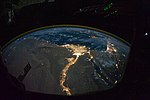 Nildeltat nattbild.
 Nilen och Nildeltat.
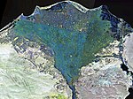 NASA satellitfoto av Nildelat (ej naturliga färger).
Media som används på denna webbplats

Författare/Upphovsman: Tkgd2007, Licens: CC BY-SA 3.0
A new incarnation of Image:Question_book-3.svg, which was uploaded by user AzaToth. This file is available on the English version of Wikipedia under the filename en:Image:Question book-new.svg


Shiny red button/marker widget. Used to mark the location of something such as a tourist attraction.
Författare/Upphovsman: Eric Gaba (Sting - fr:Sting) and NordNordWest, Licens: CC BY-SA 3.0
Physical location map of Egypt.
- Showing new governorate boundaries since 14 April 2011, after the dissolution of the 6th of October and Helwan Governorates.
- Also showing the Libyan Desert and its northern Qattara Depression, and the northern Eastern Desert.

Landsat 7 false colour image of the Nile Delta

Супутниковий знімок дельти Нілу і Синайського півострова, Єгипет, 5 лютого 2003 року.

In this view of Egypt, we see a population almost completely concentrated along the Nile Valley, just a small percentage of the country’s land area. The Nile River and its delta look like a brilliant, long-stemmed flower in this astronaut photograph of the south-eastern Mediterranean Sea, as seen from the International Space Station. The Cairo metropolitan area forms a particularly bright base of the flower. The smaller cities and towns within the Nile Delta tend to be hard to see amidst the dense agricultural vegetation during the day. However, these settled areas and the connecting roads between them become clearly visible at night. Likewise, urbanized regions and infrastructure along the Nile River becomes apparent.
Another brightly lit region is visible along the eastern coastline of the Mediterranean—the Tel-Aviv metropolitan area in Israel (image right). To the east of Tel-Aviv lies Amman, Jordan. The two major water bodies that define the western and eastern coastlines of the Sinai Peninsula—the Gulf of Suez and the Gulf of Aqaba—are outlined by lights along their coastlines (image lower right). The city lights of Paphos, Limassol, Larnaca, and Nicosia are visible on the island of Cyprus (image top).
Scattered blue-grey clouds cover the Mediterranean Sea and the Sinai, while much of north-eastern Africa is cloud-free. A thin yellow-brown band tracing the Earth’s curvature at image top is air-glow, a faint band of light emission that results from the interaction of atmospheric atoms and molecules with solar radiation at approximately 100 kilometres altitude.