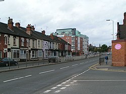
Newcastle-under-Lyme
| Newcastle-under-Lyme | |
(c) www fotodiscs4u co uk, CC BY-SA 2.0 The Guildhall (stadshuset) | |
| Land | |
|---|---|
| Riksdel | England |
| Region | West Midlands |
| Ceremoniellt grevskap | Staffordshire |
| Administrativt grevskap | Staffordshire |
| Distrikt | Newcastle-under-Lyme |
| Unparished area | Newcastle-under-Lyme |
| Koordinater | 53°00′40″N 2°13′41″V / 53.0111°N 2.2280°V |
| Folkmängd | 73 944 (2001) |
| Tidszon | UTC (UTC+0) |
| - sommartid | BST (UTC+1) |
| Geonames | 2641674 |
Läge i Storbritannien | |
Newcastle-under-Lyme, känd som "castle" för de lokala invånarna, är en handelsstad i distriktet Newcastle-under-Lyme, i grevskapet Staffordshire i regionen West Midlands i England, med 73 944 invånare (2001) i staden och 125 297 invånare i distriktet (2022)[1].
Staden är belägen väster om grannstaden Stoke-on-Trent. Deras respektive utkanter hänger ihop med varandra. Newcastles stadskärna ligger bara 3 kilometer från Stoke-on-Trent och mindre än 6 kilometer från Hanley. Newcastle ligger ungefär 27 kilometer norr om staden Stafford.
Källor
- ^ ”Estimates of the population for the UK, England, Wales, Scotland, and Northern Ireland (Mid-2022)” (på engelska) (xls). Office for National Statistics. 26 mars 2024. https://www.ons.gov.uk/peoplepopulationandcommunity/populationandmigration/populationestimates/datasets/populationestimatesforukenglandandwalesscotlandandnorthernireland. Läst 25 juni 2024.
Media som används på denna webbplats
Författare/Upphovsman: Alexrk2, Licens: CC BY-SA 3.0
Location map of the United Kingdom
Shiny red button/marker widget. Used to mark the location of something such as a tourist attraction.
(c) Malcolm Street, CC BY-SA 2.0
Floral Gardens, Newcastle-under-Lyme


