New Inn
| New Inn | |
| Community | |
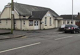
(c) Jaggery, CC BY-SA 2.0 New Inn Community Hall | |
| Land | |
|---|---|
| Riksdel | Wales |
| Kommun | Torfaen |
| Koordinater | 51°41′31″N 3°00′42″V / 51.6920°N 3.0118°V |
| Area | 11,4 km² |
| Folkmängd | 5 986 (2011)[1] |
| Befolkningstäthet | 525 invånare/km² |
| Tidszon | UTC (UTC+0) |
| - sommartid | BST (UTC+1) |
| Geonames | 3345333 7296058 |
Läge i Storbritannien | |
New Inn är en community i Storbritannien.[1] Den ligger i kommunen Torfaen och riksdelen Wales, i den södra delen av landet, 200 km väster om huvudstaden London.
Den centrala delen av New Inn är en del av tätorten Pontypool.
Källor
- ^ [a b] ”New Inn Parish”. Office for National Statistics. https://www.nomisweb.co.uk/reports/localarea?compare=W04000767. Läst 6 augusti 2022.
Media som används på denna webbplats
Författare/Upphovsman: Alexrk2, Licens: CC BY-SA 3.0
Location map of the United Kingdom
Shiny red button/marker widget. Used to mark the location of something such as a tourist attraction.
(c) Jaggery, CC BY-SA 2.0
New Inn Community Hall, New Road, New Inn. Located 50 metres from the junction with The Highway, the main road through New Inn. The building was previously Panteg Public Hall.


