New Berlin, New York
| New Berlin | |
| town | |
St. Andrew's Episcopal Church | |
| Land | |
|---|---|
| Delstat | New York |
| County | Chenango County |
| Höjdläge | 400 m ö.h. |
| Koordinater | 42°35′27″N 75°23′38″V / 42.59083°N 75.39389°V |
| Yta | 120,6 km² (2010) |
| - land | 119,5 km² |
| - vatten | 1,1 km² |
| Folkmängd | 2 682 (2010) |
| Befolkningstäthet | 22 invånare/km² |
| Tidszon | EST (UTC-5) |
| - sommartid | EDT (UTC-4) |
| ZIP-kod | 13411 |
| FIPS | 3649946 |
| Geonames | 5128466 |
(c) NordNordWest, CC BY 3.0 Ortens läge delstaten i New York | |
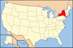
New Yorks läge i USA | |
| Webbplats: http://www.townofnewberlin.org/ | |
New Berlin är en kommun (town) i Chenango County i delstaten New York.[1] Vid 2010 års folkräkning hade New Berlin 2 682 invånare.[2]
Kända personer från New Berlin
- Anson Burlingame, politiker och diplomat
- Delazon Smith, politiker och diplomat
Källor
- ^ New Berlin, NY. Map Quest. Läst 9 juli 2021.
- ^ Postal Code of New Berlin, NY. My Zip Code. Läst 9 juli 2021.
Media som används på denna webbplats
Shiny red button/marker widget. Used to mark the location of something such as a tourist attraction.
Författare/Upphovsman: Doug Kerr from Upstate New York, Licens: CC BY-SA 2.0
St. Andrew's Episcopal Church, New Berlin, NY
Författare/Upphovsman: Huebi, Licens: CC BY 2.0
Map of USA with New York highlighted
(c) NordNordWest, CC BY 3.0
Location map of the State of New York, USA


