Neptuni åkrar
| Neptuni åkrar Naturreservat | |
 | |
| Land | Sverige |
|---|---|
| Kommun | Borgholms kommun[1] |
| Area | 24,84 hektar[1] |
| - därav vatten | 0,269 hektar[2] |
| Inrättat | 12 december 1961[1] |
| Läge | |
 Neptuni åkrar | |
| Utsträckning | |
| Områdets utsträckning. | |
| Koordinat | 57°20′54″N 17°01′51″Ö / 57.348367°N 17.030862°Ö |
| Koder, länkar, kartor | |
| IUCN- kategori | IUCN-kategori III: Naturmonument[1] |
| NVR-id | 2002275[1] (karta) |
| WDPA-id | 152419 (karta) |
| Förvaltare | Länsstyrelsen i Kalmar län[1] |
| Redigera Wikidata | |
Neptuni åkrar är ett utbrett klapperstensfält längs kusten norr om Byxelkrok i Böda socken på Öland som har inrättas som ett naturreservat. Det fick sitt namn av Carl von Linné 1741,[3] efter den romerske havsguden Neptunus. På det i övrigt nästan helt vegetationslösa strandvallarna blommar under sommaren blåeld i stor mängd..
Forgallaskeppet
På Neptuni åkrar ligger ett 150 gånger 30 meter stort gravfält som omfattar drygt 50 fornlämningar. Dessa utgörs av 32 runda stensättningar, tolv gravrösen, nio stenkistor, en skeppsformig stensättning, en treudd och en rest sten. Den skeppsformiga stensättningen benämns Forgallaskeppet och är 14 meter lång och tre meter bred. I den nordvästra spetsen finns en rest kalksten liksom i skeppets mitt. I övrigt är stensättningen flack och ofylld.
Gravarna är delvis svåra att se då de utformats av låga kalkstenshällar som är nedsatta i marken. Genom fynd, påträffade vid utgrävning utförd av T.J. Arne 1935, har gravfältet daterats till vikingatid. Den sannolikt yngsta graven, en stenkista, var på kristet vis orienterad i ost-västlig riktning.
Källor
- Länsstyrelsen om naturreservatet
- Med arkeologen Sverige runt. Bokförlaget Forum. 1987. ISBN 91-37-09153-0
- ^ [a b c d e f] Skyddade områden, naturreservat, 18 december 2015, läs onlineläs online, läst: 20 januari 2017.[källa från Wikidata]
- ^ Skyddade områden, naturreservat, 25 februari 2020, läs onlineläs online, läst: 25 februari 2020.[källa från Wikidata]
- ^ "Neptuni åkrar". Arkiverad 21 mars 2016 hämtat från the Wayback Machine. Lansstyrelsen.se. Läst 13 juni 2014.
Externa länkar
 Wikimedia Commons har media som rör Neptuni åkrar.
- Böda 5:1, Riksantikvarieämbetet.
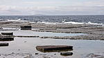 Vattenlinjen karaktäriseras av flata, nästan vågräta, hällar.
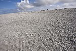 Ovanför vattenbrynet kommer en brant sluttning klädd med klappersten.
 Ovanför den branta sluttningen är klapperstensfältet sparsamt bevuxet.
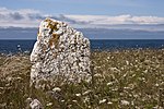 Rest sten i gravfältet.
Media som används på denna webbplats
Författare/Upphovsman: Erik Frohne, Licens: CC BY 3.0
Location map of Kalmar County in Sweden. N-S stretching is 183%, geographic limits of the map:
- N: 58.20° N
- S: 56.10° N
- W: 15.10° E
- E: 17.20° E

Shiny red button/marker widget. Used to mark the location of something such as a tourist attraction.

Författare/Upphovsman:
|

En rest sten på gravfältet på Neptuni åkrar på Öland.
Författare/Upphovsman:
|
Neptuni åkrar, ett klapperstensfält på norra Öland.

Författare/Upphovsman:
|
Neptuni åkrar, ett klapperstensfält på norra Öland.

Författare/Upphovsman:
|
Neptuni åkrar, ett klapperstensfält på norra Öland.

Författare/Upphovsman:
|
Neptuni åkrar, ett klapperstensfält på norra Öland.