Nakasatsunai
| Nakasatsunai (中札内村) | |
| Landskommun (by) | |
(c) 663highland, CC BY 2.5 Rokka-no-mori | |
| Land | |
|---|---|
| Prefektur | Hokkaidō |
| Subprefektur | Tokachi |
| Ö | Hokkaido |
| Koordinater | 42°41′53″N 143°08′03″Ö / 42.69806°N 143.13417°Ö |
| Area | 292,58 km²[1] |
| Folkmängd | 3 881 (1 okt 2022)[1] |
| Befolkningstäthet | 13 invånare/km² |
| Geonames | 7429554 |
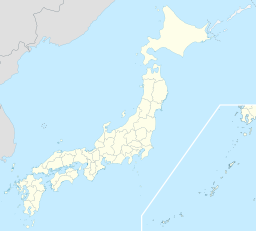
 Nakasatsunais läge i Japan | |
 Signifikanta städer Övriga städer Landskommuner | |
| Webbplats: https://www.vill.nakasatsunai.hokkaido.jp/ | |
Nakasatsunai(japanska: 中札内村?, Nakasatsunai-mura) är en landskommun (by) i Hokkaido prefektur i Japan. Den ligger cirka 25 kilometer om staden Obihiro.
I Nakasatsunai ligger Rokka-no-mori, en park med ett antal museer.
Källor
- ^ [a b] ”北海道の市区町村 Kommuner i Hokkaido prefektur”. Masahiro Higashide. https://uub.jp/cty/hokkaido.html. Läst 11 augusti 2023.
Media som används på denna webbplats
Författare/Upphovsman: Maximilian Dörrbecker (Chumwa), Licens: CC BY-SA 3.0
Location map of Japan
Equirectangular projection.
Geographic limits to locate objects in the main map with the main islands:
- N: 45°51'37" N (45.86°N)
- S: 30°01'13" N (30.02°N)
- W: 128°14'24" E (128.24°E)
- E: 149°16'13" E (149.27°E)
Geographic limits to locate objects in the side map with the Ryukyu Islands:
- N: 39°32'25" N (39.54°N)
- S: 23°42'36" N (23.71°N)
- W: 110°25'49" E (110.43°E)
- E: 131°26'25" E (131.44°E)
Shiny red button/marker widget. Used to mark the location of something such as a tourist attraction.
(c) 663highland, CC BY 2.5
Rokka no Mori in Nakasatsunai, Hokkaido prefecture, Japan.


