Nagarkot
| Nagarkot | |
| By | |
Utsikt från Nagarkot över Kathmandudalen och Himalaya. | |
| Land | |
|---|---|
| Distrikt | Bhaktapur |
| Kommun | Mahamanjushree-Nagarkot |
| Höjdläge | 2 195 m ö.h. |
| Koordinater | 27°43′6″N 85°31′5″Ö / 27.71833°N 85.51806°Ö |
| Folkmängd | 4 571 (2011) |
| Postnummer | 44812 |
| Geonames | 1283018 |
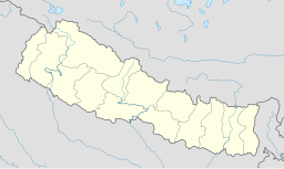
Nagarkot på kartan över Nepal. | |
Nagarkot är en by och ett populärt turistmål, 32 km öster om staden Kathmandu i distriktet Bhaktapur i Nepal.
Geografi och demografi
Lokaliserad på 2 195 meters höjd i östra Nepal, är byn belägen nära Kathmandu och 28 km från Tribhuvans internationella flygplats.[1] Byn trafikeras med bussar från den närbelägna staden Bhaktapur.
Under en folkräkning 2011 inräknades en befolkning av 4 571 personer,[2] fördelade på 973 hus.[3]
2014 uppgick byn tillsammans med ett flertal andra orter i kommunen Mahamanjushree-Nagarkot.[4]
Historia
Området, som förr kallades Mandapgiri, var tack vare sitt strategiska läge och utsikt, även av militärt intresse, och det byggdes i Nagarkot ett fort för att observera och kontrollera mänskliga aktiviteter i angränsande små kungadömen. Senare utgjorde delar av byn sommarresidens för kungafamiljen.
Turism
Den egentliga attraktionen är inte orten Nagarkot, utan blicken över de närliggande bergskedjorna, den högt belägna orten Nagarkot erbjuder en av de mest uppskattade utsikterna i distriktet, och är särskilt känt för soluppgången över Himalaya och Mount Everest i östra Nepal, något som gjort Nagarkot till ett populärt turistmål, liksom utsikten över andra delar av Himalayas bergskedjor Langtang Himal och Annapurna och ibland kan man till och med se världens 14:e högsta berg, det 8 027 meter höga berget Shishapangma.
Den bästa utsikten över de omgivande bergen är antingen tidigt på morgonen, eller under eftermiddagarnas sista timmar, när dimmorna från Himalaya inte är så tjocka, till detta tillkommer naturligtvis vädret, samt tur och otur, vilket påverkar hur mycket moln som skymmer utsikten.
Nagarkot får besök av såväl inhemska turister som internationella besökare. Genom sitt läge har Nagarkot en omfattande turism av framför allt korttidsbesökare som vill se Mount Everest, men Nagarkot erbjuder även hotell, restauranger och ett urval av aktiviteter för de som vill spendera mer en ett kort besök. Bland annat kan man följa med på den populära nagarkot eco trail (naturvandring), eller med skärmflygning avnjuta utsikten över Mount Everest.
Källor
- Den här artikeln är helt eller delvis baserad på material från engelskspråkiga Wikipedia, 19 november 2018.
Noter
- ^ ”Nagarkot Hiking”. Arkiverad från originalet den 10 januari 2022. https://web.archive.org/web/20220110043531/http://www.everestuncensored.org/nagarkot-hiking/.
- ^ ”National Population and Housing Census 2011”. Arkiverad från originalet den 13 februari 2015. https://web.archive.org/web/20150213064822/http://cbs.gov.np/wp-content/uploads/2012/11/VDC_Municipality.pdf. Läst 1 november 2012.
- ^ ”Peaceful Cottage & café du mont, Nagarkot Hillstation”. Blogspot. http://www.nagarkothotels.blogspot.com. Läst 26 augusti 2008.
- ^ ”Govt creates 61 new municipalities”. Nepal Mountain News. Arkiverad från originalet den 2 april 2015. https://web.archive.org/web/20150402093800/http://www.nepalmountainnews.com/cms/2014/12/03/78579/. Läst 19 november 2018.
Externa länkar
|
Media som används på denna webbplats
Shiny red button/marker widget. Used to mark the location of something such as a tourist attraction.
Författare/Upphovsman: Uwe Dedering, Licens: CC BY-SA 3.0
Location map of Nepal including the 14 administrative zones (outdated since 2015).
Equirectangular projection. Strechted by 113.0%. Geographic limits of the map:
* N: 31.0° N
* S: 26.0° N
* W: 79.5° E
* E: 89.0° E
Made with Natural Earth. Free vector and raster map data @ naturalearthdata.com.
Författare/Upphovsman: Uwe Gille, Licens: CC BY-SA 4.0
Kathmandu valley near Nagarkot


