Néma
| Néma | |
| النعمه | |
| Stad och Kommun | |
Néma | |
| Land | |
|---|---|
| Region | Hodh Ech Chargui |
| Departement | Néma |
| Höjdläge | 280 m ö.h. |
| Koordinater | 16°37′00″N 07°15′30″V / 16.61667°N 7.25833°V |
| Folkmängd | 21 708 (2013-03-25)[1] |
| Tidszon | GMT (UTC+0) |
| Geonames | 2377539 |
Stadens läge i Mauretanien | |
Néma är en stad i regionen Hodh Ech Chargui i sydöstra Mauretanien. Staden hade 21 708 invånare (2013).[1] Den är huvudort i regionen Hodh Ech Chargui. Den ligger nära gränsen till Mali.
Referenser
- ^ [a b] ”Mauritania: Regions, Cities & Urban Localites - Population Statistics in Maps and Charts” (på engelska). www.citypopulation.de. https://www.citypopulation.de/Mauritania-Cities.html. Läst 4 juli 2017.
Externa länkar
 Wikimedia Commons har media som rör Néma.
- Nema. Green gardens and interesting architecture
Media som används på denna webbplats
Shiny red button/marker widget. Used to mark the location of something such as a tourist attraction.
Flag of Mauritania, adopted in 2017. The National Assembly added red stripes to the top and bottom edges to represent “the blood shed by the martyrs of independence”.
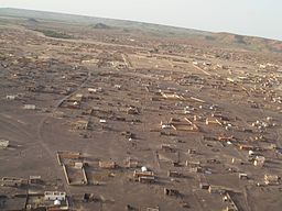
Photo taken August 2007 by an unknown US Army soldier while he was stationed in Nema for a training exchange. Photo was given to a Peace Corps Volunteer assigned to Nema in September 2007.
Författare/Upphovsman: Eric Gaba (Sting - fr:Sting), Licens: CC BY-SA 3.0
Blank administrative map of Mauritania, for geo-location purposes.


