Mulegé (kommun)
| Mulegé | ||
| Kommun | ||
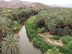
Landskap i Mulegé. | ||
| ||
| Land | ||
|---|---|---|
| Delstat | Baja California Sur | |
| Koordinater | 27°20′20″N 112°16′01″V / 27.33889°N 112.26694°V | |
| Area | 32 000,37 km²[1] | |
| Folkmängd | 63 966 (2013)[2] | |
| Befolkningstäthet | 2 invånare/km² | |
| Geonames | 6942828 | |
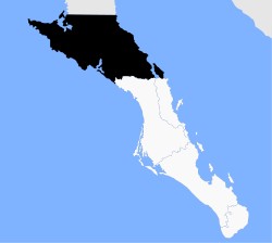
Kommunens läge i delstaten. | ||
| Webbplats: http://www.mulege.gob.mx/ | ||
Mulegé är en kommun i västra Mexiko och är belägen på halvön Baja California. Den omfattar den nordligaste delen av delstaten Baja California Sur och är med sina 33 092 km² den till ytan näst största kommunen i landet, efter Ensenada. Folkmängden uppgår till cirka 60 000 invånare. Administrativ huvudort är Santa Rosalía, medan den största orten är Guerrero Negro.
Orter
De folkrikaste orterna 2013 var:[3]
- Guerrero Negro, 13 848 invånare
- Santa Rosalía, 13 196 invånare
- Villa Alberto Andrés Alvarado Arámburo, 7 720 invånare
- Heroica Mulegé, 4 173 invånare
- Bahía Tortugas, 2 896 invånare
Källor
- ^ GeoHive; Mexico Arkiverad 16 mars 2013 hämtat från the Wayback Machine. Läst 28 december 2013.
- ^ Consejo Nacional de Población, México; Proyecciones de la Población de los Municipios de México 2010-2030 Arkiverad 21 april 2014 hämtat från the Wayback Machine. Läst 28 december 2013.
- ^ Consejo Nacional de Población, México; Proyecciones de la Población de las Localidades de México 2010-2030 (excelfil) Arkiverad 12 september 2013 hämtat från the Wayback Machine. Läst 28 december 2013.
Media som används på denna webbplats
Coat of arms of the municipality of Mulegé in Baja California Sur, Mexico
Map of Mulegé Municipality — comprising northern Baja California Sur state, northwestern México.
- Located in the mid-section of the Baja California Peninsula, with coastlines along the Gulf of California (Sea of Cortez) on the east, and the Pacific Ocean on the west.
Författare/Upphovsman: Tomás Castelazo, Licens: CC BY-SA 2.5
Mulege Oasis, Baja California Sur, Mexico


