Mont Ngaoui
| Mont Ngaoui | |
| Berg | |
| Land | |
|---|---|
| Höjdläge | 1 410 m ö.h. |
| Koordinater | 6°45′00″N 14°58′00″Ö / 6.75°N 14.96667°Ö |
| Tidszon | WAT (UTC+1) |
| Geonames | 2384059 |
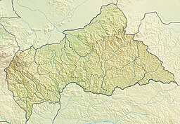
Mont Ngaoui är det högsta berget i Centralafrikanska republiken.[1] Det ligger i den västra delen av landet, 500 km nordväst om huvudstaden Bangui. Toppen på Mont Ngaoui är 1 410 meter över havet.[1]
Källor
- ^ [a b] Ali, Blaise Bienvenu, red (2018). Annuaire statistique de la république Centrafricaine, Année 2017. Bangui: Institut centrafricain des statistiques et des études économiques et sociales. sid. 1. https://icasees.org/index.php/publications/liste-des-publications/annuaire-statistique-de-la-rca-2017/download
Media som används på denna webbplats
Författare/Upphovsman: Carport, Licens: CC BY-SA 3.0
Physical location map of the Central African Republic
Shiny red button/marker widget. Used to mark the location of something such as a tourist attraction.


