Mingäçevirreservoaren
| Mingäçevirreservoaren (Mingəçevir su anbarı) | |
| Mingäçevir su anbarı | |
| reservoar | |
Flygbild med staden Mingäçevir nedtill. | |
| Land | |
|---|---|
| Flod | Kura |
| Höjdläge | 70 m ö.h. |
| Koordinater | 40°55′30″N 46°47′44″Ö / 40.92503°N 46.79565°Ö |
| Area | 417,61 km² |
| Tidszon | AZT (UTC+4) |
| - sommartid | AZST (UTC+5) |
| Geonames | 585513 |
Mingäçevirreservoaren (azerbajdzjanska: Mingəçevir su anbarı) är ett vattenmagasin i Azerbajdzjan.[1] Det ligger i den centrala delen av landet, 270 km väster om huvudstaden Baku. Mingäçevirreservoaren ligger 70 meter över havet.[a] Arean är 418 kvadratkilometer. Den sträcker sig 28,9 kilometer i nord-sydlig riktning, och 52,9 kilometer i öst-västlig riktning.
Reservoaren är anlagd på en sträcka av floden Kura. Bifloderna Iori och Alazani ansluter också här. Vid reservoaren ligger staden Mingäçevir.
Runt Mingäçevirreservoaren är det ganska glesbefolkat, med 43 invånare per kvadratkilometer.[3]
Kommentarer
Källor
- ^ Mingechaur Sea, GeoNames.Org (cc-by); post uppdaterad 2013-10-04; databasdump nerladdad 2015-12-01
- ^ ”Viewfinder Panoramas Digital elevation Model”. http://www.viewfinderpanoramas.org/dem3.html. Läst 21 juni 2015.
- ^ ”NASA Earth Observations: Population Density”. NASA/SEDAC. Arkiverad från originalet den 9 februari 2016. https://web.archive.org/web/20160209064446/http://neo.sci.gsfc.nasa.gov/view.php?datasetId=SEDAC_POP. Läst 30 januari 2016.
Media som används på denna webbplats
Författare/Upphovsman: Tschubby, Licens: CC BY-SA 3.0
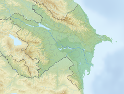
Reliefkarte Aserbaidschan
Shiny red button/marker widget. Used to mark the location of something such as a tourist attraction.
This detailed astronaut photograph highlights the southern Mingachevir Reservoir in north-central Azerbaijan. Folded layers of relatively young (less than 5. 3 million years old) sedimentary rock, explosive volcanic products (ash and tuff), and unconsolidated sediments form the grey hills along the northern and southern shorelines of the reservoir (image centre and right). Afternoon sun highlights distinctive parallel patterns in the hills that are the result of water and wind erosion of different rock layers exposed at the surface. The nearby city of Mingachevir (left) is split by the Kur River after it passes through the dam and hydroelectric power station complex at image top centre. The reservoir held approximately 15 billion cubic meters of water at the time this image was taken, with a total engineered capacity of 16 billion cubic meters. The width of the reservoir illustrated here is approximately 8 kilometres; a jet flying over the reservoir left a contrail midway between the shorelines.


