Milton, West Virginia
| Milton | |
| Stad (town) | |
| Land | |
|---|---|
| Delstat | |
| County | Cabell County |
| Höjdläge | 178 m ö.h. |
| Koordinater | 38°26′10″N 82°8′0″V / 38.43611°N 82.13333°V |
| Area | 4,1 km² (2010)[1] |
| Folkmängd | 2 811 (2020)[2] |
| Befolkningstäthet | 686 invånare/km² |
| Tidszon | EST (UTC-5) |
| - sommartid | EDT (UTC-4) |
| Riktnummer | 304 |
| GNIS-kod | 1543433 |
| Geonames | 4815044 |
Översiktskarta | |
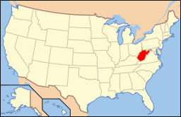
West Virginias läge i USA | |
| Wikimedia Commons: Milton, West Virginia | |
| Webbplats: http://www.thecityofmiltonwv.com/ | |
| Redigera Wikidata | |
Milton är en ort i Cabell County i delstaten West Virginia, USA.
Referenser
- ^ United States Census 2010, läs online, läst: 9 juli 2020.[källa från Wikidata]
- ^ United States Census Bureau (red.), USA:s folkräkning 2020, läs online, läst: 1 januari 2022.[källa från Wikidata]
Media som används på denna webbplats
Författare/Upphovsman: This version: uploader
Base versions this one is derived from: originally created by en:User:Wapcaplet, Licens: CC BY 2.0
Map of USA with West Virginia highlighted
Författare/Upphovsman: Tim Kiser (w:User:Malepheasant), Licens: CC BY-SA 3.0 us
Main Street along w:U.S. Route 60 in w:Milton, West Virginia. Route 60 is at left.
Författare/Upphovsman: Rcsprinter123, Licens: CC BY 3.0
Map showing the location of this town within Cabell County, West Virginia. Data source: 2010 U.S. census


