Milford, Michigan
| Milford | |
| By (village) | |
| Land | |
|---|---|
| Delstat | |
| County | Oakland County |
| Höjdläge | 288 m ö.h. |
| Koordinater | 42°35′37″N 83°35′58″V / 42.59361°N 83.59944°V |
| Area | 6,53 km² (2010)[2] |
| Folkmängd | 6 520 (2020)[3] |
| Befolkningstäthet | 999 invånare/km² |
| Grundad | 1832[1] |
| Tidszon | EST (UTC-5) |
| - sommartid | EDT (UTC-4) |
| Riktnummer | 248 |
| GNIS-kod | 632306 |
| Geonames | 5001972 |
Översiktskarta | |
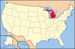
Michigans läge i USA | |
| Wikimedia Commons: Milford, Michigan | |
| Webbplats: https://www.villageofmilford.org/ | |
| Redigera Wikidata | |
Milford är en ort (village) i Oakland County i Michigan.[4] Vid 2010 års folkräkning hade Milford 6 175 invånare.[5]
Källor
- ^ härlett från: Kategori:Orter grundade 1832, läst: 9 november 2018.[källa från Wikidata]
- ^ United States Census Bureau, 2010 U.S. Gazetteer Files, United States Census Bureau, 2010, läst: 9 juli 2020.[källa från Wikidata]
- ^ United States Census Bureau (red.), USA:s folkräkning 2020, läs online, läst: 1 januari 2022.[källa från Wikidata]
- ^ Milford, MI. Map Quest. Läst 25 december 2019.
- ^ 2010 Census Population of Milford, Michigan Arkiverad 25 december 2019 hämtat från the Wayback Machine.. Census Viewer. Läst 25 december 2019.
|
Media som används på denna webbplats
Författare/Upphovsman:
| This media | uploader |
|---|---|
| Original work | en:User:Wapcaplet |
Map of USA with Michigan highlighted
Författare/Upphovsman: Dwight Burdette, Licens: CC BY 3.0
Village of Milford Michigan Civic Center, 1100 Atlantic Street, Milford, Michigan. The building houses the offices of both Milford Township and the separately administered Village of Milford.
Författare/Upphovsman: Arkyan, Licens: CC BY-SA 3.0
This map shows the incorporated and unincorporated areas in Oakland County, Michigan, highlighting Milford in red. I created it in Inkscape using data from the US Census Bureau.


