Middelalderparken
| Middelalderparken | |
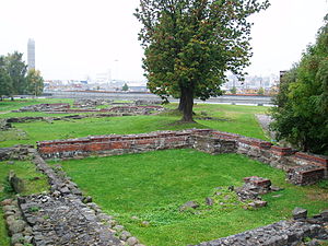
 Middelalderparken sedd från Ekeberg, 2010 | |
| Plats | |
|---|---|
| Plats | Medeltidsstaden, Gamlebyen, Oslo |
| Land | Norge |
| Administration | |
| Grundad | 2000 |
| Grundare | Oslo kommun |
| Övrigt | |
Middelalderparken är en norsk park i Medeltidsstaden i stadsdelen Gamle Oslo i Oslo. Parken öppnades 2000. Den ligger i Sörenga, söder om Bispegata och öster om Kong Håkon 5.s gate. Parken är en del av ett tänkt framtida sammanhängande kulturstråk, som också skulle inkludera Minneparken och Ladegården på den norra sidan av Bispegata.
I Middelalderparken ligger Saxegården och ruinerna av Sankt Clemenskirken, Mariakirken och Kongsgården. Intill Middelalderparken i väster har tagits fram en vattenspegel som rekonstruerar Björvikas tidigare strandlinje. Parken var ursprungligen på 70 hektar. Med det 2022 pågående järnvägsprojektet Follobanen görs en övertäckning av banområdet vid parken, ovanpå vilken Middelalderparken kommer att utvidgas väsentligt.[2]
Alnaelva har sitt utlopp i den södra delen av parken. Under tidigt 1900-tal lades flodens nedre lopp i kulvertar. Mynningen har rekonstruerats så att floden leder ut i parkens vattenspegel.
Oslo Middelalderfestival och Øyafestivalen har till och med 2013 arrangerats årligen i parken. Från 2014 är dessa på grund av bygget av Follobanen flyttad till respektive Akershus fästning och Tøyenparken.
Bildgalleri
 Ruinen av Kongsgården, 2008
 Parken sedd från Barcode. Kong Håkon 5.s gate under anläggning till höger, 2014
 Ingången vid Saxegården, 2009
 Ruinen av Mariakirken i förgrunden och Barcode i Bjørvika i bakgrunden, 2009
 Mariakirkeruinen sett mot Järnvägsverkstaden och Saxegården, 2008
 Parken med den återskapade mynningen av Alnaelva, sett från Kong Håkon 5.s gate, 2014
 Parken sedd från Kong Håkon 5.s gate, 2014
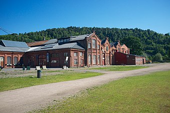 Järnvägsverkstaden, 2014
Källor
Noter
- ^ hämtat från: engelskspråkiga Wikipedia.[källa från Wikidata]
- ^ "Konkurranse om utforming av Middelalderparken", artikel från Jernbaneverket 14 augusti 2013
Externa länkar
 Wikimedia Commons har media som rör Middelalderparken.
| |||||||||||||
{{#coordinates:}}: kan inte ha mer än en primär tagg per sida
Media som används på denna webbplats
.jpg)
No. XLIX. CITY OF CHRISTIANIA.
|
|---|
|
This view was taken from a position recommended by the late honourable Bernard Anker, on the side of a mountain called Egeberg, from whence the city of Christiania, and its noble background of mountains, are seen to the greatest advantage, on which account the spot is the pride of the inhabitants, and the admiration of foreigners. At the bottom of the hill on the right, are some remains of the old city of Opsloe, which was burnt in the year 1624. The buildings on the left, are Opsloe Kirke, and a lunatic hospital. A new road winds on to the right, between some good houses and the ancient palace belonging to the bishops of this see, a high gothic building, with red tiles, seen on the right margin of the picture. This edifice was the residence of the kings and princes of Denmark, in their visits to the city. Across the bay, on the gentle declivity of the hills, is situated the new city, denominated Christiania. Its principal object on the left is the ancient garrison, called Aggerhus, with its fortifications and walls, projected on a rocky peninsula, at the extremity of the city ; to the right are observed the red warehouses, wharfs, and ships in the harbour, up to the custom house ; in succession are seen the hospitable quadrangular mansion, and garden of the Ankers ; the cathedral church, the museum, hospitais, schools, prison, &c. &c Situated on a middle hill, is seen the ancient church called Aggers, and at a greater elevation near the margin, is Ulivold, the seat of John Collett, Esq. Numerous villas are interspersed among the high grounds, as far as Bogstad, which is situated at the feet of the distant hills, nearly over the great church. In the vale below Aggers, is the botanic garden, and not far distant from it, is the site of the new Royal University, now erecting, with residences for nineteen professors, and two lecturers. Parallel with the town, is a long slip of land, from the bridge to below the custom house, having the river on one side, and the bay on the other; on it are the extensive timber and deal-yards, covered rope-yards, places for careening ships, great cranes for putting in their masts, &c. &c. The ships proceed to and from sea, under the walls of the garrison, in the deep water. The other part of this spacious bay, between Christiania and Opsloe, is navigable for boats only, being choaked up with the saw-dust perpetually descending into it from the numerous saw-mills up the river, although a machine is continually at work to remove it. The new road from the city on the foreground, winds up over Egeberg, and leads on to Mos, Frederickstad, Swinesund, and Sweden. The approach to Christiania on this side, is over the summit of the mountain, where on emerging from a forest, the traveller obtains his first view of the city, spread out before him in its whole extent, and producing with its beautiful and magnificent scenery, a grand and most picturesque effect. The prospect is pronounced by tourists, to be unequalled in Europe. The supreme governor of Norway, resides in this town, and the high court of justice is held here. Christiania is also the seat of the primate bishop, who with three others, exercises the ecclesiastical jurisdiction of all Norway. The garrison, under the superintendance of a commandant, has its hospital and school. There is another hospital for the town. The trade is often very considerable, and there is an abundant supply of all sorts of game, provisions, and foreign delicacies. The inhabitants are hospitable and friendly ; scarcely a traveller enters it, without receiving invitations from the opulent, to their public tables.
|

Författare/Upphovsman: Helge Høifødt, Licens: CC BY-SA 4.0
Mariakirkeruinen i Middelalderparken, sett mot Saxegården

Författare/Upphovsman: Øystein H. Brekke, Licens: CC BY-SA 3.0 no
i databasen för Direktoratet för kulturminnesförvaltning.

Författare/Upphovsman: Helge Høifødt, Licens: CC BY-SA 4.0
Middelalderparken sett fra Kong Håkon 5.s gate

Författare/Upphovsman: Kjetil Ree, Licens: CC BY-SA 3.0
Fra Middelalderparken i Oslo.

Författare/Upphovsman: Helge Høifødt, Licens: CC BY-SA 3.0
Middelalderparken, Gamlebyen, Oslo, ruins of Maria Church in front, view to "Barcode", Bjørvika under construction

Författare/Upphovsman: Helge Høifødt, Licens: CC BY-SA 4.0
Middelalderparken, Gamlebyen i Oslo, sett fra Barcode. Kong Håkon 5.s gate under anlegg til høyre

Författare/Upphovsman: Helge Høifødt, Licens: CC BY-SA 3.0
Middelalderparken, Gamlebyen, Oslo, entrance from Østre strete bru, Saxegården i the middle of the picture
Författare/Upphovsman: Helge Høifødt, Licens: CC BY-SA 3.0
Middelalderparken, seen fram Ekeberg

Författare/Upphovsman: Helge Høifødt, Licens: CC BY-SA 4.0
Middelalderparken med Alnas utløp sett fra Kong Håkon 5.s gate